You are here: Home > Network List > CI - Caltech Regional Seismic Network Stations List
> Station VCS Vincent Substation, Palmdale, CA, USA > Earthquake Result Viewer
VCS Vincent Substation, Palmdale, CA, USA - Earthquake Result Viewer
| Earthquake location: |
Near Coast Of Guatemala |
| Earthquake latitude/longitude: |
13.6/-90.6 |
| Earthquake time(UTC): |
2007/06/13 (164) 19:29:40 GMT |
| Earthquake Depth: |
23 km |
| Earthquake Magnitude: |
5.9 MB, 6.5 MS, 6.7 MW, 6.5 MW |
| Earthquake Catalog/Contributor: |
WHDF/NEIC |
|
| Network: |
CI Caltech Regional Seismic Network |
| Station: |
VCS Vincent Substation, Palmdale, CA, USA |
| Lat/Lon: |
34.48 N/118.12 W |
| Elevation: |
991 m |
|
| Distance: |
32.5 deg |
| Az: |
314.7 deg |
| Baz: |
123.195 deg |
| Ray Param: |
0.078618415 |
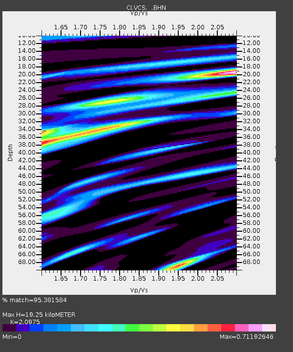
| Estimated Moho Depth: |
19.25 km |
| Estimated Crust Vp/Vs: |
2.10 |
| Assumed Crust Vp: |
6.1 km/s |
| Estimated Crust Vs: |
2.908 km/s |
| Estimated Crust Poisson's Ratio: |
0.35 |
|
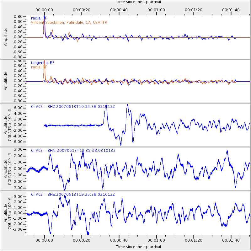
| Radial Match: |
95.381584 % |
| Radial Bump: |
400 |
| Transverse Match: |
84.37546 % |
| Transverse Bump: |
400 |
| SOD ConfigId: |
2564 |
| Insert Time: |
2010-02-25 21:06:46.334 +0000 |
| GWidth: |
2.5 |
| Max Bumps: |
400 |
| Tol: |
0.001 |
|
Signal To Noise
| Channel | StoN | STA | LTA |
| CI:VCS: :BHN:20070613T19:35:38.031013Z | 5.302831 | 1.0572638E-6 | 1.9937723E-7 |
| CI:VCS: :BHE:20070613T19:35:38.031013Z | 7.4959464 | 1.6158865E-6 | 2.1556805E-7 |
| CI:VCS: :BHZ:20070613T19:35:38.031013Z | 30.808775 | 3.2460832E-6 | 1.053623E-7 |
| Arrivals |
| Ps | 3.7 SECOND |
| PpPs | 9.2 SECOND |
| PsPs/PpSs | 13 SECOND |


