You are here: Home > Network List > TA - USArray Transportable Network (new EarthScope stations) Stations List
> Station E64A Bridgewater, ME, USA > Earthquake Result Viewer
E64A Bridgewater, ME, USA - Earthquake Result Viewer

| Earthquake location: |
Off Coast Of Jalisco, Mexico |
| Earthquake latitude/longitude: |
18.9/-107.4 |
| Earthquake time(UTC): |
2014/05/31 (151) 11:53:48 GMT |
| Earthquake Depth: |
10 km |
| Earthquake Magnitude: |
6.2 MWP, 6.6 MI |
| Earthquake Catalog/Contributor: |
NEIC PDE/NEIC COMCAT |
|
| Network: |
TA USArray Transportable Network (new EarthScope stations) |
| Station: |
E64A Bridgewater, ME, USA |
| Lat/Lon: |
46.42 N/67.83 W |
| Elevation: |
190 m |
|
| Distance: |
42.6 deg |
| Az: |
40.711 deg |
| Baz: |
243.235 deg |
| Ray Param: |
0.07310646 |
| Estimated Moho Depth: |
24.5 km |
| Estimated Crust Vp/Vs: |
1.99 |
| Assumed Crust Vp: |
6.419 km/s |
| Estimated Crust Vs: |
3.23 km/s |
| Estimated Crust Poisson's Ratio: |
0.33 |
|
| Radial Match: |
89.960396 % |
| Radial Bump: |
384 |
| Transverse Match: |
58.455532 % |
| Transverse Bump: |
400 |
| SOD ConfigId: |
626651 |
| Insert Time: |
2014-06-14 12:30:39.682 +0000 |
| GWidth: |
2.5 |
| Max Bumps: |
400 |
| Tol: |
0.001 |
|
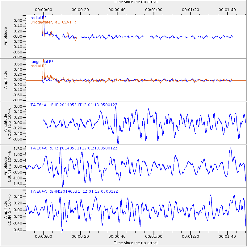
Signal To Noise
| Channel | StoN | STA | LTA |
| TA:E64A: :BHZ:20140531T12:01:13.050012Z | 4.6576557 | 4.9490853E-7 | 1.06257005E-7 |
| TA:E64A: :BHN:20140531T12:01:13.050012Z | 2.2558386 | 1.8046546E-7 | 7.999928E-8 |
| TA:E64A: :BHE:20140531T12:01:13.050012Z | 2.3439186 | 2.3607134E-7 | 1.00716534E-7 |
| Arrivals |
| Ps | 4.0 SECOND |
| PpPs | 11 SECOND |
| PsPs/PpSs | 15 SECOND |


