You are here: Home > Network List > TA - USArray Transportable Network (new EarthScope stations) Stations List
> Station G46A Petoskey, MI, USA > Earthquake Result Viewer
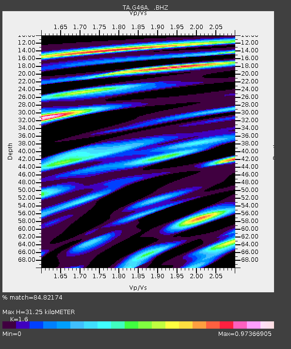
G46A Petoskey, MI, USA - Earthquake Result Viewer
| Earthquake location: |
Off Coast Of Jalisco, Mexico |
| Earthquake latitude/longitude: |
18.9/-107.4 |
| Earthquake time(UTC): |
2014/05/31 (151) 11:53:48 GMT |
| Earthquake Depth: |
10 km |
| Earthquake Magnitude: |
6.2 MWP, 6.6 MI |
| Earthquake Catalog/Contributor: |
NEIC PDE/NEIC COMCAT |
|
| Network: |
TA USArray Transportable Network (new EarthScope stations) |
| Station: |
G46A Petoskey, MI, USA |
| Lat/Lon: |
45.32 N/84.86 W |
| Elevation: |
239 m |
|
| Distance: |
32.4 deg |
| Az: |
30.397 deg |
| Baz: |
222.777 deg |
| Ray Param: |
0.078678064 |
| Estimated Moho Depth: |
31.25 km |
| Estimated Crust Vp/Vs: |
1.60 |
| Assumed Crust Vp: |
6.483 km/s |
| Estimated Crust Vs: |
4.052 km/s |
| Estimated Crust Poisson's Ratio: |
0.18 |
|
| Radial Match: |
84.82174 % |
| Radial Bump: |
400 |
| Transverse Match: |
46.657455 % |
| Transverse Bump: |
400 |
| SOD ConfigId: |
626651 |
| Insert Time: |
2014-06-14 12:31:41.864 +0000 |
| GWidth: |
2.5 |
| Max Bumps: |
400 |
| Tol: |
0.001 |
|

Signal To Noise
| Channel | StoN | STA | LTA |
| TA:G46A: :BHZ:20140531T11:59:47.024988Z | 5.003541 | 7.213265E-7 | 1.4416321E-7 |
| TA:G46A: :BHN:20140531T11:59:47.024988Z | 3.2261379 | 6.6245576E-7 | 2.053402E-7 |
| TA:G46A: :BHE:20140531T11:59:47.024988Z | 2.8537316 | 5.8081173E-7 | 2.0352711E-7 |
| Arrivals |
| Ps | 3.2 SECOND |
| PpPs | 11 SECOND |
| PsPs/PpSs | 15 SECOND |


