ABKT Alibek, Turkmenistan - Earthquake Result Viewer
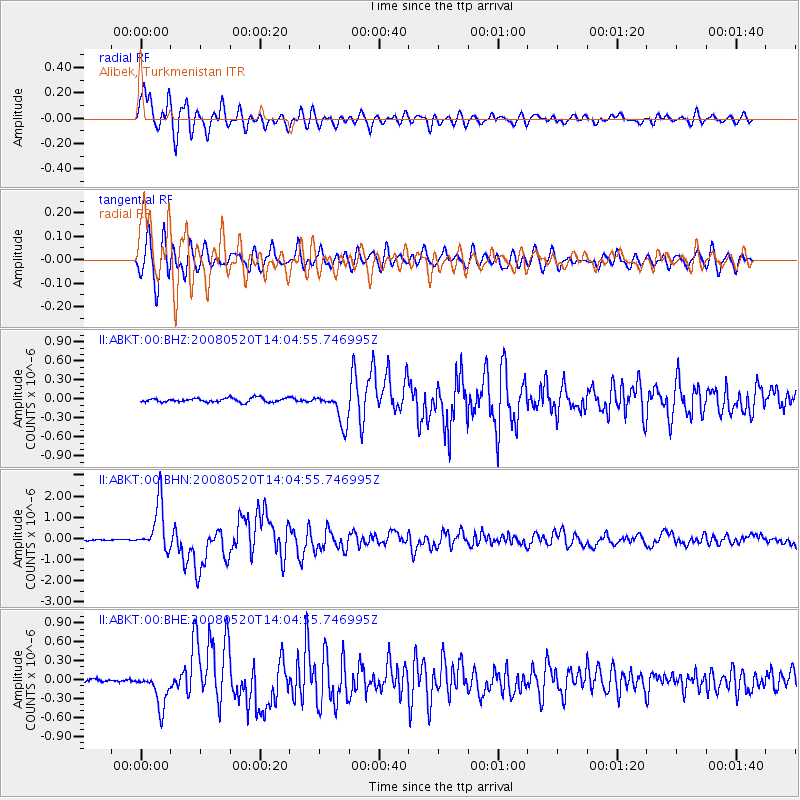
Earthquake location: Rat Islands, Aleutian Islands
Earthquake latitude/longitude: 51.2/178.8
Earthquake time(UTC): 2008/05/20 (141) 13:53:35 GMT
Earthquake Depth: 27 km
Earthquake Magnitude: 5.8 MB, 6.0 MS, 6.3 MW, 6.3 MW
Earthquake Catalog/Contributor: WHDF/NEIC
Network: II Global Seismograph Network (GSN - IRIS/IDA)
Station: ABKT Alibek, Turkmenistan
Lat/Lon: 37.93 N/58.12 E
Elevation: 678 m
Distance: 77.2 deg
Az: 315.755 deg
Baz: 33.752 deg
Ray Param: 0.050459396
Estimated Moho Depth: 12.0 km
Estimated Crust Vp/Vs: 1.67
Assumed Crust Vp: 6.53 km/s
Estimated Crust Vs: 3.905 km/s
Estimated Crust Poisson's Ratio: 0.22
Radial Match: 94.800316 %
Radial Bump: 400
Transverse Match: 89.186554 %
Transverse Bump: 400
SOD ConfigId: 2504
Insert Time: 2010-03-01 22:44:37.973 +0000
GWidth: 2.5
Max Bumps: 400
Tol: 0.001

Signal To Noise

ChannelStoNSTALTA
II:ABKT:00:BHN:20080520T14:04:55.746995Z29.8808631.1228551E-63.757773E-8
II:ABKT:00:BHE:20080520T14:04:55.746995Z12.4883042.7567833E-72.2074921E-8
II:ABKT:00:BHZ:20080520T14:04:55.746995Z7.91690442.5262193E-73.190918E-8
Arrivals
Ps1.3 SECOND
PpPs4.7 SECOND
PsPs/PpSs6.0 SECOND