You are here: Home > Network List > TA - USArray Transportable Network (new EarthScope stations) Stations List
> Station I63A Otisfield, ME, USA > Earthquake Result Viewer
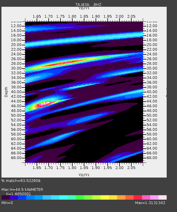
I63A Otisfield, ME, USA - Earthquake Result Viewer
| Earthquake location: |
Off Coast Of Jalisco, Mexico |
| Earthquake latitude/longitude: |
18.9/-107.4 |
| Earthquake time(UTC): |
2014/05/31 (151) 11:53:48 GMT |
| Earthquake Depth: |
10 km |
| Earthquake Magnitude: |
6.2 MWP, 6.6 MI |
| Earthquake Catalog/Contributor: |
NEIC PDE/NEIC COMCAT |
|
| Network: |
TA USArray Transportable Network (new EarthScope stations) |
| Station: |
I63A Otisfield, ME, USA |
| Lat/Lon: |
44.05 N/70.58 W |
| Elevation: |
177 m |
|
| Distance: |
39.7 deg |
| Az: |
42.572 deg |
| Baz: |
242.688 deg |
| Ray Param: |
0.07480492 |
| Estimated Moho Depth: |
44.5 km |
| Estimated Crust Vp/Vs: |
1.69 |
| Assumed Crust Vp: |
6.419 km/s |
| Estimated Crust Vs: |
3.81 km/s |
| Estimated Crust Poisson's Ratio: |
0.23 |
|
| Radial Match: |
93.532906 % |
| Radial Bump: |
228 |
| Transverse Match: |
72.36283 % |
| Transverse Bump: |
400 |
| SOD ConfigId: |
626651 |
| Insert Time: |
2014-06-14 12:34:52.220 +0000 |
| GWidth: |
2.5 |
| Max Bumps: |
400 |
| Tol: |
0.001 |
|

Signal To Noise
| Channel | StoN | STA | LTA |
| TA:I63A: :BHZ:20140531T12:00:49.975Z | 4.5801687 | 5.861567E-7 | 1.279771E-7 |
| TA:I63A: :BHN:20140531T12:00:49.975Z | 3.2300246 | 2.2534513E-7 | 6.976577E-8 |
| TA:I63A: :BHE:20140531T12:00:49.975Z | 1.9262936 | 2.574369E-7 | 1.3364364E-7 |
| Arrivals |
| Ps | 5.1 SECOND |
| PpPs | 17 SECOND |
| PsPs/PpSs | 22 SECOND |


