You are here: Home > Network List > TA - USArray Transportable Network (new EarthScope stations) Stations List
> Station J45A Montague, MI, USA > Earthquake Result Viewer
J45A Montague, MI, USA - Earthquake Result Viewer
| Earthquake location: |
Off Coast Of Jalisco, Mexico |
| Earthquake latitude/longitude: |
18.9/-107.4 |
| Earthquake time(UTC): |
2014/05/31 (151) 11:53:48 GMT |
| Earthquake Depth: |
10 km |
| Earthquake Magnitude: |
6.2 MWP, 6.6 MI |
| Earthquake Catalog/Contributor: |
NEIC PDE/NEIC COMCAT |
|
| Network: |
TA USArray Transportable Network (new EarthScope stations) |
| Station: |
J45A Montague, MI, USA |
| Lat/Lon: |
43.44 N/86.39 W |
| Elevation: |
209 m |
|
| Distance: |
30.3 deg |
| Az: |
31.299 deg |
| Baz: |
222.484 deg |
| Ray Param: |
0.07938145 |
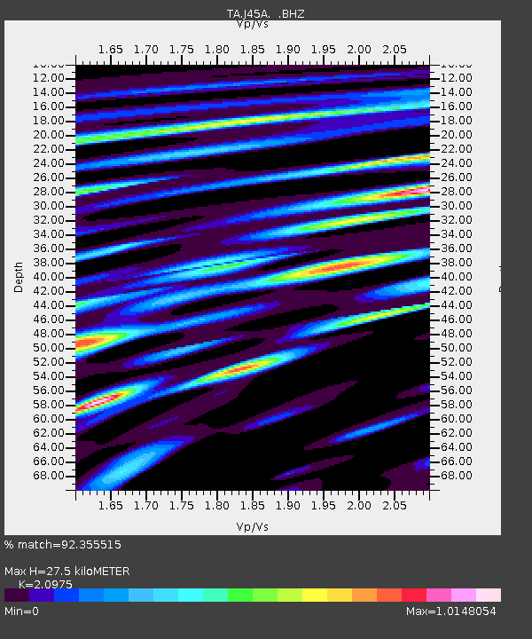
| Estimated Moho Depth: |
27.5 km |
| Estimated Crust Vp/Vs: |
2.10 |
| Assumed Crust Vp: |
6.483 km/s |
| Estimated Crust Vs: |
3.091 km/s |
| Estimated Crust Poisson's Ratio: |
0.35 |
|
| Radial Match: |
92.355515 % |
| Radial Bump: |
400 |
| Transverse Match: |
73.38009 % |
| Transverse Bump: |
400 |
| SOD ConfigId: |
626651 |
| Insert Time: |
2014-06-14 12:35:01.097 +0000 |
| GWidth: |
2.5 |
| Max Bumps: |
400 |
| Tol: |
0.001 |
|
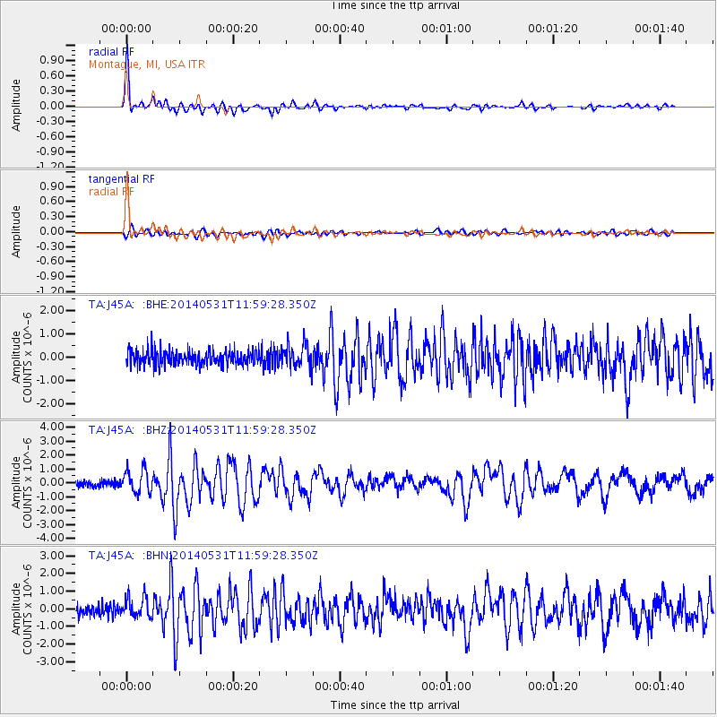
Signal To Noise
| Channel | StoN | STA | LTA |
| TA:J45A: :BHZ:20140531T11:59:28.350Z | 3.9960766 | 8.3764604E-7 | 2.0961711E-7 |
| TA:J45A: :BHN:20140531T11:59:28.350Z | 2.3634784 | 5.938687E-7 | 2.5126894E-7 |
| TA:J45A: :BHE:20140531T11:59:28.350Z | 1.6090016 | 4.960409E-7 | 3.082911E-7 |
| Arrivals |
| Ps | 5.0 SECOND |
| PpPs | 12 SECOND |
| PsPs/PpSs | 17 SECOND |


