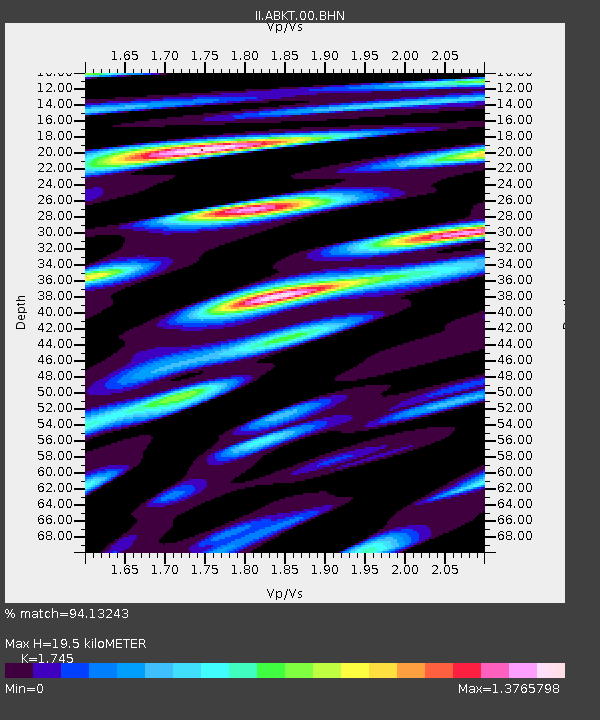
ABKT Alibek, Turkmenistan - Earthquake Result Viewer

Earthquake location: Andaman Islands, India Region
Earthquake latitude/longitude: 11.0/91.8
Earthquake time(UTC): 2008/06/27 (179) 11:40:13 GMT
Earthquake Depth: 17 km
Earthquake Magnitude: 6.4 MB, 6.7 MS, 6.6 MW, 6.6 MW
Earthquake Catalog/Contributor: WHDF/NEIC
Network: II Global Seismograph Network (GSN - IRIS/IDA)
Station: ABKT Alibek, Turkmenistan
Lat/Lon: 37.93 N/58.12 E
Elevation: 678 m
Distance: 40.4 deg
Az: 317.344 deg
Baz: 122.717 deg
Ray Param: 0.07442841
Estimated Moho Depth: 19.5 km
Estimated Crust Vp/Vs: 1.75
Assumed Crust Vp: 6.53 km/s
Estimated Crust Vs: 3.742 km/s
Estimated Crust Poisson's Ratio: 0.26
Radial Match: 94.13243 %
Radial Bump: 400
Transverse Match: 86.51045 %
Transverse Bump: 400
SOD ConfigId: 2504
Insert Time: 2010-03-01 22:44:59.675 +0000
GWidth: 2.5
Max Bumps: 400
Tol: 0.001

Signal To Noise

ChannelStoNSTALTA
II:ABKT:00:BHN:20080627T11:47:19.906992Z41.571042.2427375E-65.3949513E-8
II:ABKT:00:BHE:20080627T11:47:19.906992Z30.12148.814327E-72.9262674E-8
II:ABKT:00:BHZ:20080627T11:47:19.906992Z19.8492368.4080386E-74.2359506E-8
Arrivals
Ps2.4 SECOND
PpPs7.6 SECOND
PsPs/PpSs10 SECOND