You are here: Home > Network List > TA - USArray Transportable Network (new EarthScope stations) Stations List
> Station L58A Harry Jones Memorial, Binghamton, NY, USA > Earthquake Result Viewer
L58A Harry Jones Memorial, Binghamton, NY, USA - Earthquake Result Viewer
| Earthquake location: |
Off Coast Of Jalisco, Mexico |
| Earthquake latitude/longitude: |
18.9/-107.4 |
| Earthquake time(UTC): |
2014/05/31 (151) 11:53:48 GMT |
| Earthquake Depth: |
10 km |
| Earthquake Magnitude: |
6.2 MWP, 6.6 MI |
| Earthquake Catalog/Contributor: |
NEIC PDE/NEIC COMCAT |
|
| Network: |
TA USArray Transportable Network (new EarthScope stations) |
| Station: |
L58A Harry Jones Memorial, Binghamton, NY, USA |
| Lat/Lon: |
42.04 N/75.85 W |
| Elevation: |
447 m |
|
| Distance: |
35.4 deg |
| Az: |
42.35 deg |
| Baz: |
238.926 deg |
| Ray Param: |
0.077244505 |
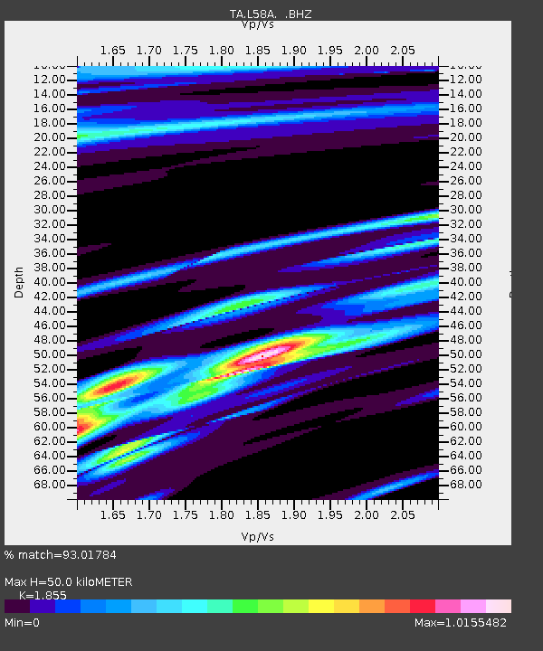
| Estimated Moho Depth: |
50.0 km |
| Estimated Crust Vp/Vs: |
1.86 |
| Assumed Crust Vp: |
6.419 km/s |
| Estimated Crust Vs: |
3.461 km/s |
| Estimated Crust Poisson's Ratio: |
0.30 |
|
| Radial Match: |
93.01784 % |
| Radial Bump: |
173 |
| Transverse Match: |
70.727585 % |
| Transverse Bump: |
400 |
| SOD ConfigId: |
626651 |
| Insert Time: |
2014-06-14 12:37:13.594 +0000 |
| GWidth: |
2.5 |
| Max Bumps: |
400 |
| Tol: |
0.001 |
|

Signal To Noise
| Channel | StoN | STA | LTA |
| TA:L58A: :BHZ:20140531T12:00:13.225Z | 6.552976 | 6.985326E-7 | 1.0659776E-7 |
| TA:L58A: :BHN:20140531T12:00:13.225Z | 3.086531 | 2.6210503E-7 | 8.491897E-8 |
| TA:L58A: :BHE:20140531T12:00:13.225Z | 6.030044 | 3.942864E-7 | 6.5386985E-8 |
| Arrivals |
| Ps | 7.2 SECOND |
| PpPs | 21 SECOND |
| PsPs/PpSs | 28 SECOND |


