You are here: Home > Network List > II - Global Seismograph Network (GSN - IRIS/IDA) Stations List
> Station ABKT Alibek, Turkmenistan > Earthquake Result Viewer
ABKT Alibek, Turkmenistan - Earthquake Result Viewer
| Earthquake location: |
Taiwan Region |
| Earthquake latitude/longitude: |
21.0/121.1 |
| Earthquake time(UTC): |
2008/07/13 (195) 14:58:32 GMT |
| Earthquake Depth: |
10 km |
| Earthquake Magnitude: |
5.6 MB, 6.3 MS, 6.2 MW, 6.1 MW |
| Earthquake Catalog/Contributor: |
WHDF/NEIC |
|
| Network: |
II Global Seismograph Network (GSN - IRIS/IDA) |
| Station: |
ABKT Alibek, Turkmenistan |
| Lat/Lon: |
37.93 N/58.12 E |
| Elevation: |
678 m |
|
| Distance: |
56.4 deg |
| Az: |
302.216 deg |
| Baz: |
88.458 deg |
| Ray Param: |
0.06416517 |
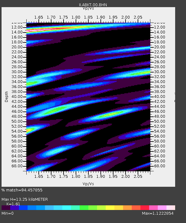
| Estimated Moho Depth: |
13.25 km |
| Estimated Crust Vp/Vs: |
1.61 |
| Assumed Crust Vp: |
6.53 km/s |
| Estimated Crust Vs: |
4.056 km/s |
| Estimated Crust Poisson's Ratio: |
0.19 |
|
| Radial Match: |
94.457855 % |
| Radial Bump: |
400 |
| Transverse Match: |
88.689186 % |
| Transverse Bump: |
400 |
| SOD ConfigId: |
2504 |
| Insert Time: |
2010-03-01 22:45:11.159 +0000 |
| GWidth: |
2.5 |
| Max Bumps: |
400 |
| Tol: |
0.001 |
|

Signal To Noise
| Channel | StoN | STA | LTA |
| II:ABKT:00:BHN:20080713T15:07:42.787012Z | 7.7117333 | 2.5596663E-7 | 3.3191842E-8 |
| II:ABKT:00:BHE:20080713T15:07:42.787012Z | 0.632614 | 1.5882588E-8 | 2.5106285E-8 |
| II:ABKT:00:BHZ:20080713T15:07:42.787012Z | 2.746611 | 9.487866E-8 | 3.4543902E-8 |
| Arrivals |
| Ps | 1.3 SECOND |
| PpPs | 5.0 SECOND |
| PsPs/PpSs | 6.3 SECOND |


