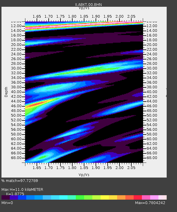
ABKT Alibek, Turkmenistan - Earthquake Result Viewer
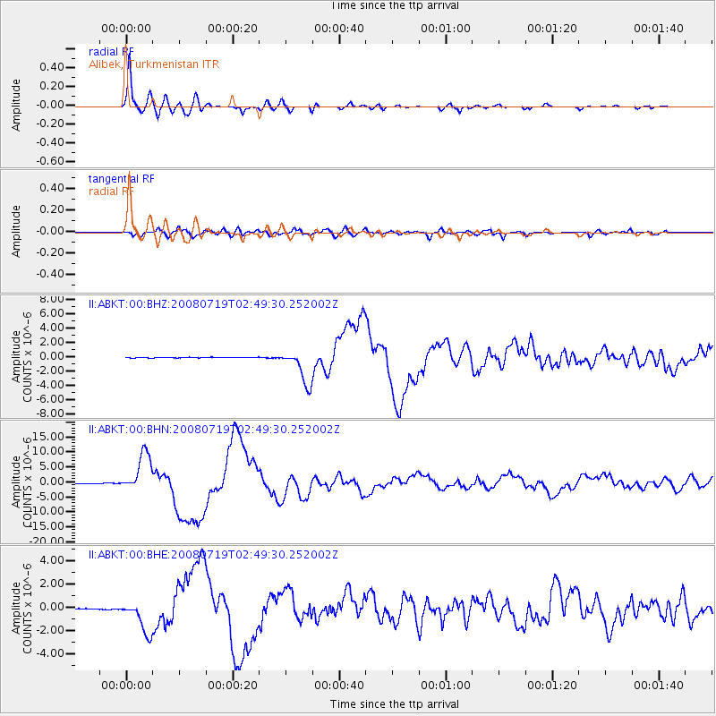
Earthquake location: Off East Coast Of Honshu, Japan
Earthquake latitude/longitude: 37.6/142.2
Earthquake time(UTC): 2008/07/19 (201) 02:39:28 GMT
Earthquake Depth: 22 km
Earthquake Magnitude: 6.2 MB, 7.0 MS, 7.0 MW, 6.9 MW
Earthquake Catalog/Contributor: WHDF/NEIC
Network: II Global Seismograph Network (GSN - IRIS/IDA)
Station: ABKT Alibek, Turkmenistan
Lat/Lon: 37.93 N/58.12 E
Elevation: 678 m
Distance: 64.1 deg
Az: 299.063 deg
Baz: 61.465 deg
Ray Param: 0.05908815
Estimated Moho Depth: 11.0 km
Estimated Crust Vp/Vs: 1.88
Assumed Crust Vp: 6.53 km/s
Estimated Crust Vs: 3.478 km/s
Estimated Crust Poisson's Ratio: 0.30
Radial Match: 97.72789 %
Radial Bump: 400
Transverse Match: 85.03766 %
Transverse Bump: 400
SOD ConfigId: 2504
Insert Time: 2010-03-01 22:45:12.763 +0000
GWidth: 2.5
Max Bumps: 400
Tol: 0.001

Signal To Noise

ChannelStoNSTALTA
II:ABKT:00:BHN:20080719T02:49:30.252002Z90.575616.6484695E-67.3402425E-8
II:ABKT:00:BHE:20080719T02:49:30.252002Z36.968591.4290505E-63.8655802E-8
II:ABKT:00:BHZ:20080719T02:49:30.252002Z57.9406782.448091E-64.225168E-8
Arrivals
Ps1.5 SECOND
PpPs4.6 SECOND
PsPs/PpSs6.2 SECOND