You are here: Home > Network List > TA - USArray Transportable Network (new EarthScope stations) Stations List
> Station M53A WI Miller and Sons, Farmdale, OH, USA > Earthquake Result Viewer
M53A WI Miller and Sons, Farmdale, OH, USA - Earthquake Result Viewer
| Earthquake location: |
Off Coast Of Jalisco, Mexico |
| Earthquake latitude/longitude: |
18.9/-107.4 |
| Earthquake time(UTC): |
2014/05/31 (151) 11:53:48 GMT |
| Earthquake Depth: |
10 km |
| Earthquake Magnitude: |
6.2 MWP, 6.6 MI |
| Earthquake Catalog/Contributor: |
NEIC PDE/NEIC COMCAT |
|
| Network: |
TA USArray Transportable Network (new EarthScope stations) |
| Station: |
M53A WI Miller and Sons, Farmdale, OH, USA |
| Lat/Lon: |
41.44 N/80.68 W |
| Elevation: |
334 m |
|
| Distance: |
32.1 deg |
| Az: |
39.638 deg |
| Baz: |
233.468 deg |
| Ray Param: |
0.07881161 |
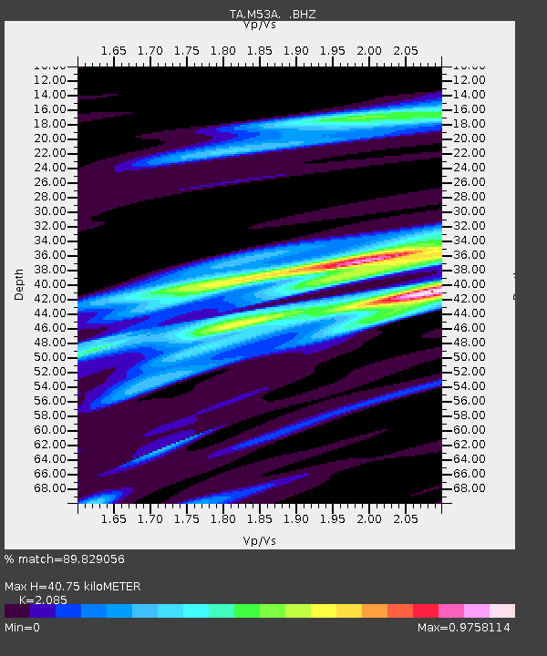
| Estimated Moho Depth: |
40.75 km |
| Estimated Crust Vp/Vs: |
2.09 |
| Assumed Crust Vp: |
6.483 km/s |
| Estimated Crust Vs: |
3.109 km/s |
| Estimated Crust Poisson's Ratio: |
0.35 |
|
| Radial Match: |
89.829056 % |
| Radial Bump: |
189 |
| Transverse Match: |
65.524155 % |
| Transverse Bump: |
400 |
| SOD ConfigId: |
626651 |
| Insert Time: |
2014-06-14 12:37:50.097 +0000 |
| GWidth: |
2.5 |
| Max Bumps: |
400 |
| Tol: |
0.001 |
|

Signal To Noise
| Channel | StoN | STA | LTA |
| TA:M53A: :BHZ:20140531T11:59:44.274988Z | 7.8226123 | 8.3094426E-7 | 1.0622337E-7 |
| TA:M53A: :BHN:20140531T11:59:44.274988Z | 5.6843824 | 3.39876E-7 | 5.97912E-8 |
| TA:M53A: :BHE:20140531T11:59:44.274988Z | 5.540295 | 4.5612805E-7 | 8.23292E-8 |
| Arrivals |
| Ps | 7.3 SECOND |
| PpPs | 18 SECOND |
| PsPs/PpSs | 25 SECOND |


