You are here: Home > Network List > TA - USArray Transportable Network (new EarthScope stations) Stations List
> Station M63A Gales Ferry, CT, USA > Earthquake Result Viewer
M63A Gales Ferry, CT, USA - Earthquake Result Viewer
| Earthquake location: |
Off Coast Of Jalisco, Mexico |
| Earthquake latitude/longitude: |
18.9/-107.4 |
| Earthquake time(UTC): |
2014/05/31 (151) 11:53:48 GMT |
| Earthquake Depth: |
10 km |
| Earthquake Magnitude: |
6.2 MWP, 6.6 MI |
| Earthquake Catalog/Contributor: |
NEIC PDE/NEIC COMCAT |
|
| Network: |
TA USArray Transportable Network (new EarthScope stations) |
| Station: |
M63A Gales Ferry, CT, USA |
| Lat/Lon: |
41.40 N/72.05 W |
| Elevation: |
44 m |
|
| Distance: |
37.6 deg |
| Az: |
45.581 deg |
| Baz: |
244.047 deg |
| Ray Param: |
0.07604968 |
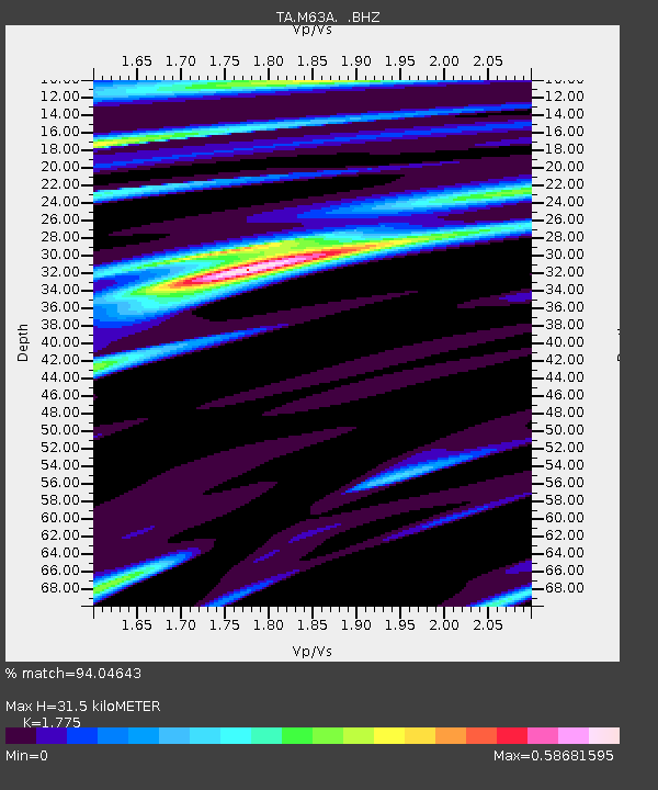
| Estimated Moho Depth: |
31.5 km |
| Estimated Crust Vp/Vs: |
1.77 |
| Assumed Crust Vp: |
6.472 km/s |
| Estimated Crust Vs: |
3.646 km/s |
| Estimated Crust Poisson's Ratio: |
0.27 |
|
| Radial Match: |
94.04643 % |
| Radial Bump: |
260 |
| Transverse Match: |
82.94761 % |
| Transverse Bump: |
364 |
| SOD ConfigId: |
626651 |
| Insert Time: |
2014-06-14 12:38:26.671 +0000 |
| GWidth: |
2.5 |
| Max Bumps: |
400 |
| Tol: |
0.001 |
|

Signal To Noise
| Channel | StoN | STA | LTA |
| TA:M63A: :BHZ:20140531T12:00:31.925012Z | 9.111549 | 1.0293274E-6 | 1.1296952E-7 |
| TA:M63A: :BHN:20140531T12:00:31.925012Z | 2.0702977 | 2.182014E-7 | 1.0539614E-7 |
| TA:M63A: :BHE:20140531T12:00:31.925012Z | 6.4673567 | 6.8974225E-7 | 1.0664979E-7 |
| Arrivals |
| Ps | 4.1 SECOND |
| PpPs | 13 SECOND |
| PsPs/PpSs | 17 SECOND |


