You are here: Home > Network List > TA - USArray Transportable Network (new EarthScope stations) Stations List
> Station N53A Lisbon, OH, USA > Earthquake Result Viewer
N53A Lisbon, OH, USA - Earthquake Result Viewer
| Earthquake location: |
Off Coast Of Jalisco, Mexico |
| Earthquake latitude/longitude: |
18.9/-107.4 |
| Earthquake time(UTC): |
2014/05/31 (151) 11:53:48 GMT |
| Earthquake Depth: |
10 km |
| Earthquake Magnitude: |
6.2 MWP, 6.6 MI |
| Earthquake Catalog/Contributor: |
NEIC PDE/NEIC COMCAT |
|
| Network: |
TA USArray Transportable Network (new EarthScope stations) |
| Station: |
N53A Lisbon, OH, USA |
| Lat/Lon: |
40.81 N/80.84 W |
| Elevation: |
360 m |
|
| Distance: |
31.6 deg |
| Az: |
40.467 deg |
| Baz: |
234.066 deg |
| Ray Param: |
0.079012685 |
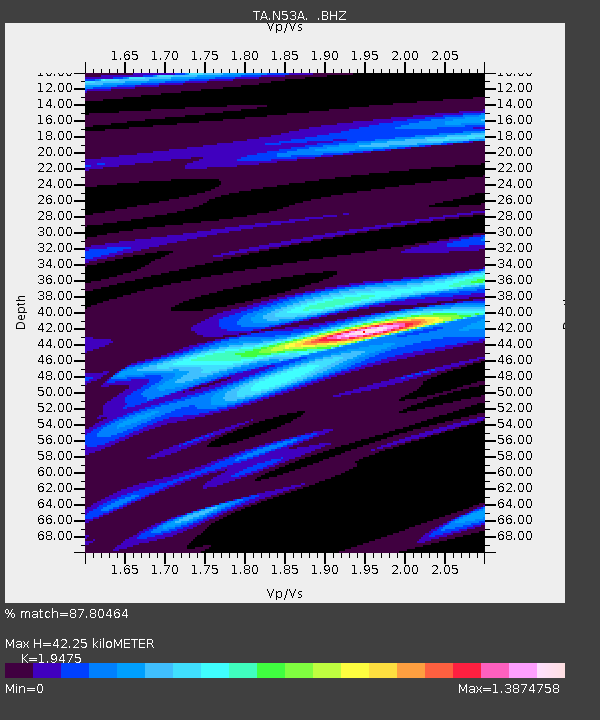
| Estimated Moho Depth: |
42.25 km |
| Estimated Crust Vp/Vs: |
1.95 |
| Assumed Crust Vp: |
6.483 km/s |
| Estimated Crust Vs: |
3.329 km/s |
| Estimated Crust Poisson's Ratio: |
0.32 |
|
| Radial Match: |
87.80464 % |
| Radial Bump: |
265 |
| Transverse Match: |
62.345314 % |
| Transverse Bump: |
400 |
| SOD ConfigId: |
626651 |
| Insert Time: |
2014-06-14 12:38:48.891 +0000 |
| GWidth: |
2.5 |
| Max Bumps: |
400 |
| Tol: |
0.001 |
|
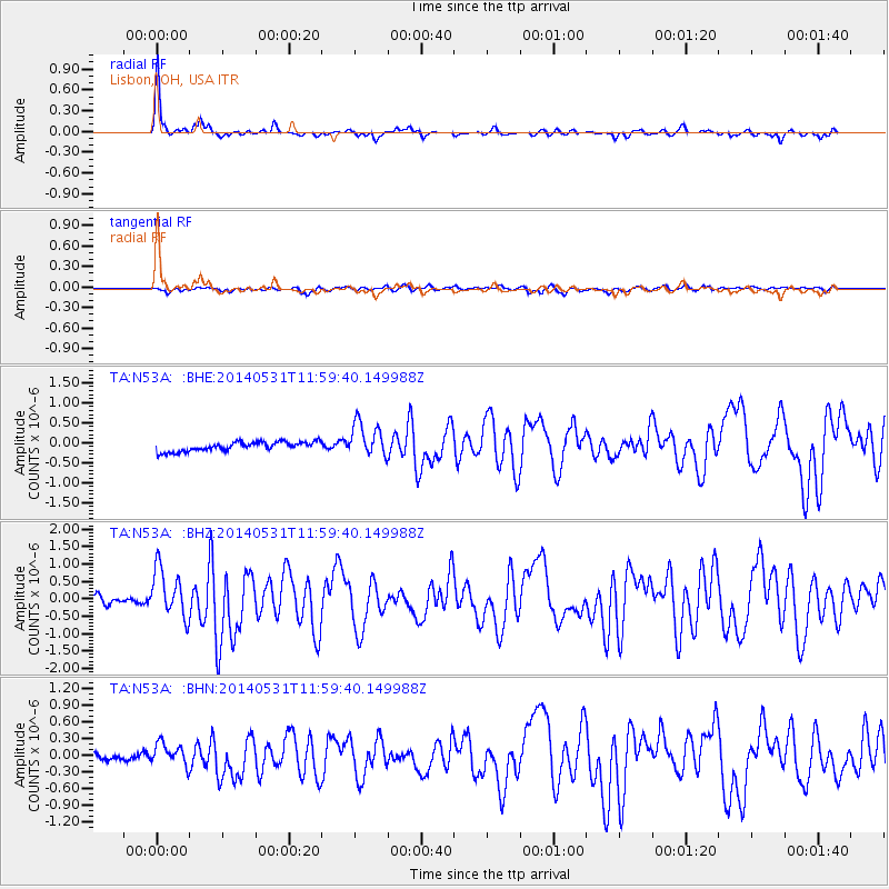
Signal To Noise
| Channel | StoN | STA | LTA |
| TA:N53A: :BHZ:20140531T11:59:40.149988Z | 7.0624223 | 7.044411E-7 | 9.974497E-8 |
| TA:N53A: :BHN:20140531T11:59:40.149988Z | 2.5643928 | 1.868424E-7 | 7.286029E-8 |
| TA:N53A: :BHE:20140531T11:59:40.149988Z | 3.7561028 | 4.3442697E-7 | 1.1565897E-7 |
| Arrivals |
| Ps | 6.6 SECOND |
| PpPs | 18 SECOND |
| PsPs/PpSs | 24 SECOND |


