You are here: Home > Network List > II - Global Seismograph Network (GSN - IRIS/IDA) Stations List
> Station ABKT Alibek, Turkmenistan > Earthquake Result Viewer
ABKT Alibek, Turkmenistan - Earthquake Result Viewer
| Earthquake location: |
Banda Sea |
| Earthquake latitude/longitude: |
-5.9/130.2 |
| Earthquake time(UTC): |
2008/08/04 (217) 20:45:13 GMT |
| Earthquake Depth: |
174 km |
| Earthquake Magnitude: |
6.1 MB, 6.3 MW, 6.2 MW |
| Earthquake Catalog/Contributor: |
WHDF/NEIC |
|
| Network: |
II Global Seismograph Network (GSN - IRIS/IDA) |
| Station: |
ABKT Alibek, Turkmenistan |
| Lat/Lon: |
37.93 N/58.12 E |
| Elevation: |
678 m |
|
| Distance: |
79.7 deg |
| Az: |
310.112 deg |
| Baz: |
105.83 deg |
| Ray Param: |
0.048380084 |
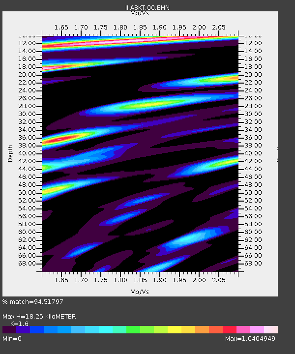
| Estimated Moho Depth: |
18.25 km |
| Estimated Crust Vp/Vs: |
1.60 |
| Assumed Crust Vp: |
6.53 km/s |
| Estimated Crust Vs: |
4.082 km/s |
| Estimated Crust Poisson's Ratio: |
0.18 |
|
| Radial Match: |
94.51797 % |
| Radial Bump: |
400 |
| Transverse Match: |
88.857414 % |
| Transverse Bump: |
400 |
| SOD ConfigId: |
2504 |
| Insert Time: |
2010-03-01 22:45:25.367 +0000 |
| GWidth: |
2.5 |
| Max Bumps: |
400 |
| Tol: |
0.001 |
|
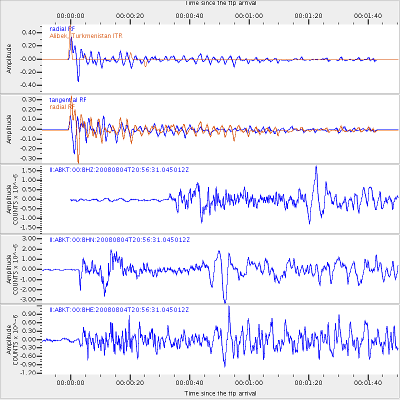
Signal To Noise
| Channel | StoN | STA | LTA |
| II:ABKT:00:BHN:20080804T20:56:31.045012Z | 11.654701 | 5.7295114E-7 | 4.9160516E-8 |
| II:ABKT:00:BHE:20080804T20:56:31.045012Z | 5.396184 | 1.4603394E-7 | 2.7062448E-8 |
| II:ABKT:00:BHZ:20080804T20:56:31.045012Z | 2.321034 | 9.723629E-8 | 4.189352E-8 |
| Arrivals |
| Ps | 1.7 SECOND |
| PpPs | 7.0 SECOND |
| PsPs/PpSs | 8.8 SECOND |


