You are here: Home > Network List > TA - USArray Transportable Network (new EarthScope stations) Stations List
> Station P59A Jarrettsville, MD, USA > Earthquake Result Viewer
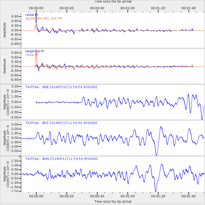
P59A Jarrettsville, MD, USA - Earthquake Result Viewer

| Earthquake location: |
Off Coast Of Jalisco, Mexico |
| Earthquake latitude/longitude: |
18.9/-107.4 |
| Earthquake time(UTC): |
2014/05/31 (151) 11:53:48 GMT |
| Earthquake Depth: |
10 km |
| Earthquake Magnitude: |
6.2 MWP, 6.6 MI |
| Earthquake Catalog/Contributor: |
NEIC PDE/NEIC COMCAT |
|
| Network: |
TA USArray Transportable Network (new EarthScope stations) |
| Station: |
P59A Jarrettsville, MD, USA |
| Lat/Lon: |
39.61 N/76.43 W |
| Elevation: |
157 m |
|
| Distance: |
33.8 deg |
| Az: |
45.676 deg |
| Baz: |
241.285 deg |
| Ray Param: |
0.07803942 |
| Estimated Moho Depth: |
41.5 km |
| Estimated Crust Vp/Vs: |
1.60 |
| Assumed Crust Vp: |
6.419 km/s |
| Estimated Crust Vs: |
4.012 km/s |
| Estimated Crust Poisson's Ratio: |
0.18 |
|
| Radial Match: |
92.51784 % |
| Radial Bump: |
291 |
| Transverse Match: |
80.311905 % |
| Transverse Bump: |
400 |
| SOD ConfigId: |
626651 |
| Insert Time: |
2014-06-14 12:40:31.120 +0000 |
| GWidth: |
2.5 |
| Max Bumps: |
400 |
| Tol: |
0.001 |
|
Signal To Noise
| Channel | StoN | STA | LTA |
| TA:P59A: :BHZ:20140531T11:59:59.450006Z | 6.4499702 | 6.517483E-7 | 1.01046716E-7 |
| TA:P59A: :BHN:20140531T11:59:59.450006Z | 1.923695 | 1.9986761E-7 | 1.0389777E-7 |
| TA:P59A: :BHE:20140531T11:59:59.450006Z | 8.127199 | 5.0162936E-7 | 6.172229E-8 |
| Arrivals |
| Ps | 4.2 SECOND |
| PpPs | 15 SECOND |
| PsPs/PpSs | 20 SECOND |


