You are here: Home > Network List > TA - USArray Transportable Network (new EarthScope stations) Stations List
> Station P60A Greenville, DE, USA > Earthquake Result Viewer
P60A Greenville, DE, USA - Earthquake Result Viewer
| Earthquake location: |
Off Coast Of Jalisco, Mexico |
| Earthquake latitude/longitude: |
18.9/-107.4 |
| Earthquake time(UTC): |
2014/05/31 (151) 11:53:48 GMT |
| Earthquake Depth: |
10 km |
| Earthquake Magnitude: |
6.2 MWP, 6.6 MI |
| Earthquake Catalog/Contributor: |
NEIC PDE/NEIC COMCAT |
|
| Network: |
TA USArray Transportable Network (new EarthScope stations) |
| Station: |
P60A Greenville, DE, USA |
| Lat/Lon: |
39.81 N/75.64 W |
| Elevation: |
105 m |
|
| Distance: |
34.4 deg |
| Az: |
45.881 deg |
| Baz: |
241.962 deg |
| Ray Param: |
0.07774091 |
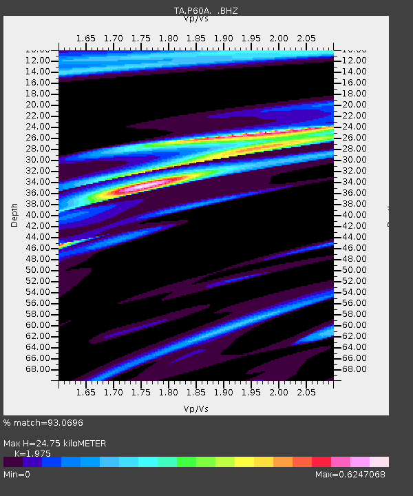
| Estimated Moho Depth: |
24.75 km |
| Estimated Crust Vp/Vs: |
1.98 |
| Assumed Crust Vp: |
6.287 km/s |
| Estimated Crust Vs: |
3.184 km/s |
| Estimated Crust Poisson's Ratio: |
0.33 |
|
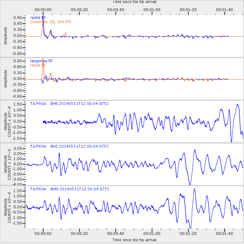
| Radial Match: |
93.0696 % |
| Radial Bump: |
285 |
| Transverse Match: |
82.43956 % |
| Transverse Bump: |
400 |
| SOD ConfigId: |
626651 |
| Insert Time: |
2014-06-14 12:40:34.926 +0000 |
| GWidth: |
2.5 |
| Max Bumps: |
400 |
| Tol: |
0.001 |
|
Signal To Noise
| Channel | StoN | STA | LTA |
| TA:P60A: :BHZ:20140531T12:00:04.975Z | 10.01772 | 7.133814E-7 | 7.121195E-8 |
| TA:P60A: :BHN:20140531T12:00:04.975Z | 4.272199 | 2.8729556E-7 | 6.72477E-8 |
| TA:P60A: :BHE:20140531T12:00:04.975Z | 4.3458686 | 3.461006E-7 | 7.9638994E-8 |
| Arrivals |
| Ps | 4.1 SECOND |
| PpPs | 11 SECOND |
| PsPs/PpSs | 15 SECOND |


