You are here: Home > Network List > TA - USArray Transportable Network (new EarthScope stations) Stations List
> Station S58A Poland Farm, Powhatan, VA, USA > Earthquake Result Viewer
S58A Poland Farm, Powhatan, VA, USA - Earthquake Result Viewer
| Earthquake location: |
Off Coast Of Jalisco, Mexico |
| Earthquake latitude/longitude: |
18.9/-107.4 |
| Earthquake time(UTC): |
2014/05/31 (151) 11:53:48 GMT |
| Earthquake Depth: |
10 km |
| Earthquake Magnitude: |
6.2 MWP, 6.6 MI |
| Earthquake Catalog/Contributor: |
NEIC PDE/NEIC COMCAT |
|
| Network: |
TA USArray Transportable Network (new EarthScope stations) |
| Station: |
S58A Poland Farm, Powhatan, VA, USA |
| Lat/Lon: |
37.61 N/78.05 W |
| Elevation: |
96 m |
|
| Distance: |
31.7 deg |
| Az: |
47.808 deg |
| Baz: |
242.072 deg |
| Ray Param: |
0.07894836 |
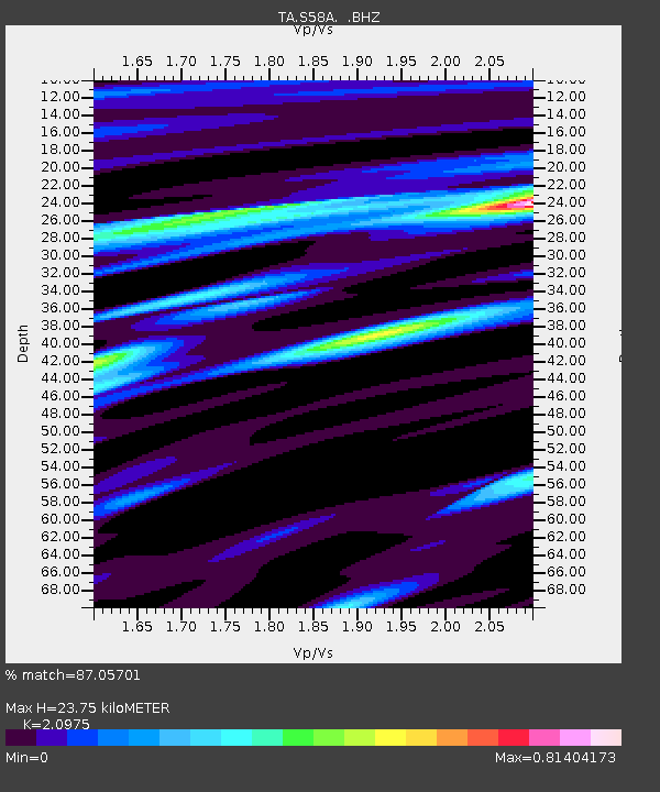
| Estimated Moho Depth: |
23.75 km |
| Estimated Crust Vp/Vs: |
2.10 |
| Assumed Crust Vp: |
6.419 km/s |
| Estimated Crust Vs: |
3.06 km/s |
| Estimated Crust Poisson's Ratio: |
0.35 |
|
| Radial Match: |
87.05701 % |
| Radial Bump: |
351 |
| Transverse Match: |
73.01629 % |
| Transverse Bump: |
400 |
| SOD ConfigId: |
626651 |
| Insert Time: |
2014-06-14 12:41:53.256 +0000 |
| GWidth: |
2.5 |
| Max Bumps: |
400 |
| Tol: |
0.001 |
|

Signal To Noise
| Channel | StoN | STA | LTA |
| TA:S58A: :BHZ:20140531T11:59:41.475Z | 7.8823185 | 7.7912347E-7 | 9.884446E-8 |
| TA:S58A: :BHN:20140531T11:59:41.475Z | 3.7657218 | 2.6427028E-7 | 7.0177855E-8 |
| TA:S58A: :BHE:20140531T11:59:41.475Z | 5.2222958 | 4.5207133E-7 | 8.6565635E-8 |
| Arrivals |
| Ps | 4.3 SECOND |
| PpPs | 11 SECOND |
| PsPs/PpSs | 15 SECOND |


