You are here: Home > Network List > TA - USArray Transportable Network (new EarthScope stations) Stations List
> Station S59A Mechanicsville, VA, USA > Earthquake Result Viewer
S59A Mechanicsville, VA, USA - Earthquake Result Viewer
| Earthquake location: |
Off Coast Of Jalisco, Mexico |
| Earthquake latitude/longitude: |
18.9/-107.4 |
| Earthquake time(UTC): |
2014/05/31 (151) 11:53:48 GMT |
| Earthquake Depth: |
10 km |
| Earthquake Magnitude: |
6.2 MWP, 6.6 MI |
| Earthquake Catalog/Contributor: |
NEIC PDE/NEIC COMCAT |
|
| Network: |
TA USArray Transportable Network (new EarthScope stations) |
| Station: |
S59A Mechanicsville, VA, USA |
| Lat/Lon: |
37.46 N/77.18 W |
| Elevation: |
40 m |
|
| Distance: |
32.3 deg |
| Az: |
48.669 deg |
| Baz: |
243.333 deg |
| Ray Param: |
0.07871587 |
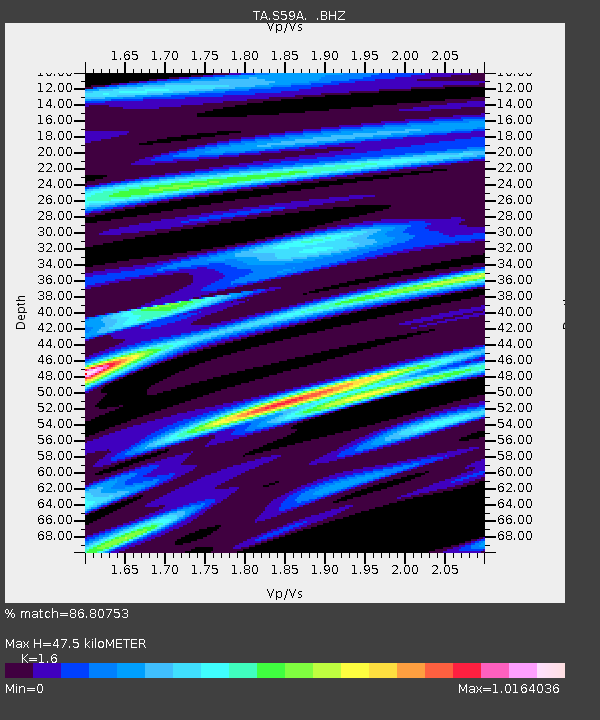
| Estimated Moho Depth: |
47.5 km |
| Estimated Crust Vp/Vs: |
1.60 |
| Assumed Crust Vp: |
6.565 km/s |
| Estimated Crust Vs: |
4.103 km/s |
| Estimated Crust Poisson's Ratio: |
0.18 |
|
| Radial Match: |
86.80753 % |
| Radial Bump: |
400 |
| Transverse Match: |
62.48659 % |
| Transverse Bump: |
400 |
| SOD ConfigId: |
626651 |
| Insert Time: |
2014-06-14 12:41:56.105 +0000 |
| GWidth: |
2.5 |
| Max Bumps: |
400 |
| Tol: |
0.001 |
|

Signal To Noise
| Channel | StoN | STA | LTA |
| TA:S59A: :BHZ:20140531T11:59:46.725Z | 9.25591 | 9.786712E-7 | 1.0573474E-7 |
| TA:S59A: :BHN:20140531T11:59:46.725Z | 3.325675 | 3.1943645E-7 | 9.6051615E-8 |
| TA:S59A: :BHE:20140531T11:59:46.725Z | 6.154862 | 6.821108E-7 | 1.1082471E-7 |
| Arrivals |
| Ps | 4.8 SECOND |
| PpPs | 17 SECOND |
| PsPs/PpSs | 22 SECOND |


