You are here: Home > Network List > PB - Plate Boundary Observatory Borehole Seismic Network Stations List
> Station B082 pathfi082bcs2006, Anza, CA, USA > Earthquake Result Viewer
B082 pathfi082bcs2006, Anza, CA, USA - Earthquake Result Viewer
| Earthquake location: |
Andreanof Islands, Aleutian Is. |
| Earthquake latitude/longitude: |
50.5/-173.3 |
| Earthquake time(UTC): |
2015/03/07 (066) 13:18:24 GMT |
| Earthquake Depth: |
10 km |
| Earthquake Magnitude: |
5.7 MO |
| Earthquake Catalog/Contributor: |
NEIC PDE/NEIC ALERT |
|
| Network: |
PB Plate Boundary Observatory Borehole Seismic Network |
| Station: |
B082 pathfi082bcs2006, Anza, CA, USA |
| Lat/Lon: |
33.60 N/116.60 W |
| Elevation: |
1375 m |
|
| Distance: |
44.3 deg |
| Az: |
90.088 deg |
| Baz: |
310.134 deg |
| Ray Param: |
0.07202992 |
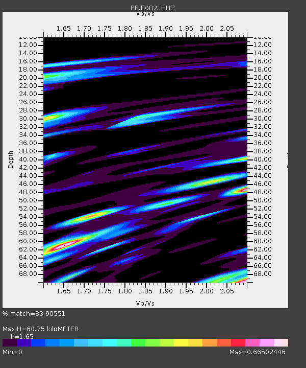
| Estimated Moho Depth: |
60.75 km |
| Estimated Crust Vp/Vs: |
1.65 |
| Assumed Crust Vp: |
6.264 km/s |
| Estimated Crust Vs: |
3.796 km/s |
| Estimated Crust Poisson's Ratio: |
0.21 |
|
| Radial Match: |
83.90551 % |
| Radial Bump: |
400 |
| Transverse Match: |
83.89894 % |
| Transverse Bump: |
400 |
| SOD ConfigId: |
7019011 |
| Insert Time: |
2019-04-17 05:52:26.771 +0000 |
| GWidth: |
2.5 |
| Max Bumps: |
400 |
| Tol: |
0.001 |
|

Signal To Noise
| Channel | StoN | STA | LTA |
| PB:B082: :HHZ:20150307T13:26:02.059015Z | 34.987194 | 6.506536E-8 | 1.8596905E-9 |
| PB:B082: :HH1:20150307T13:26:02.059015Z | 11.911902 | 2.114673E-8 | 1.7752607E-9 |
| PB:B082: :HH2:20150307T13:26:02.059015Z | 18.8577 | 2.760367E-8 | 1.4637878E-9 |
| Arrivals |
| Ps | 6.7 SECOND |
| PpPs | 24 SECOND |
| PsPs/PpSs | 31 SECOND |


