You are here: Home > Network List > US - United States National Seismic Network Stations List
> Station LONY Lake Ozonia, New York, USA > Earthquake Result Viewer
LONY Lake Ozonia, New York, USA - Earthquake Result Viewer
| Earthquake location: |
Off Coast Of Jalisco, Mexico |
| Earthquake latitude/longitude: |
18.9/-107.4 |
| Earthquake time(UTC): |
2014/05/31 (151) 11:53:48 GMT |
| Earthquake Depth: |
10 km |
| Earthquake Magnitude: |
6.2 MWP, 6.6 MI |
| Earthquake Catalog/Contributor: |
NEIC PDE/NEIC COMCAT |
|
| Network: |
US United States National Seismic Network |
| Station: |
LONY Lake Ozonia, New York, USA |
| Lat/Lon: |
44.62 N/74.58 W |
| Elevation: |
440 m |
|
| Distance: |
37.5 deg |
| Az: |
39.49 deg |
| Baz: |
237.492 deg |
| Ray Param: |
0.07607936 |
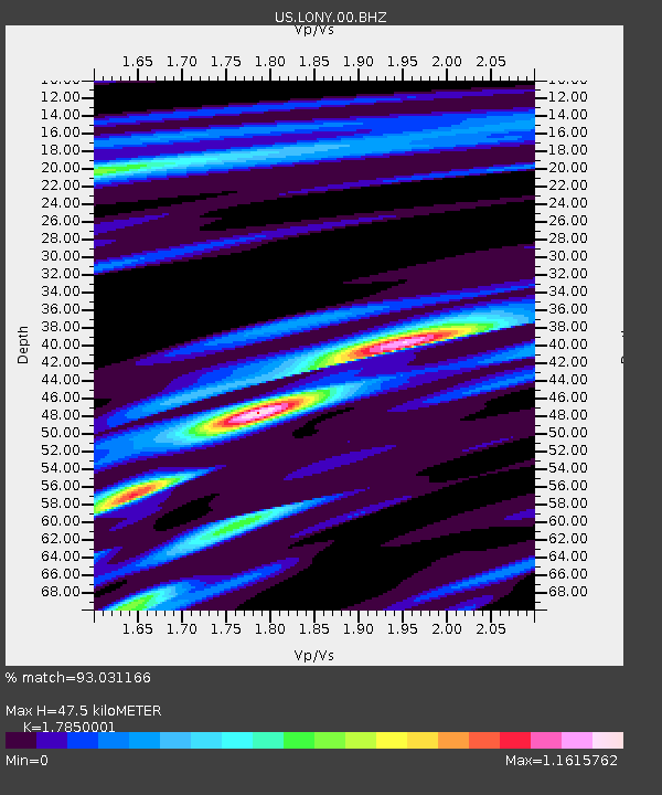
| Estimated Moho Depth: |
47.5 km |
| Estimated Crust Vp/Vs: |
1.79 |
| Assumed Crust Vp: |
6.419 km/s |
| Estimated Crust Vs: |
3.596 km/s |
| Estimated Crust Poisson's Ratio: |
0.27 |
|
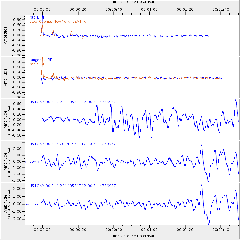
| Radial Match: |
93.031166 % |
| Radial Bump: |
258 |
| Transverse Match: |
86.359695 % |
| Transverse Bump: |
345 |
| SOD ConfigId: |
626651 |
| Insert Time: |
2014-06-14 12:44:26.692 +0000 |
| GWidth: |
2.5 |
| Max Bumps: |
400 |
| Tol: |
0.001 |
|
Signal To Noise
| Channel | StoN | STA | LTA |
| US:LONY:00:BHZ:20140531T12:00:31.473993Z | 7.014346 | 5.4167606E-7 | 7.722403E-8 |
| US:LONY:00:BH1:20140531T12:00:31.473993Z | 3.6638656 | 3.0213053E-7 | 8.2462236E-8 |
| US:LONY:00:BH2:20140531T12:00:31.473993Z | 3.8463573 | 2.5504917E-7 | 6.6309276E-8 |
| Arrivals |
| Ps | 6.2 SECOND |
| PpPs | 19 SECOND |
| PsPs/PpSs | 25 SECOND |


