You are here: Home > Network List > II - Global Seismograph Network (GSN - IRIS/IDA) Stations List
> Station ABKT Alibek, Turkmenistan > Earthquake Result Viewer
ABKT Alibek, Turkmenistan - Earthquake Result Viewer
| Earthquake location: |
Halmahera, Indonesia |
| Earthquake latitude/longitude: |
1.9/127.4 |
| Earthquake time(UTC): |
2008/09/11 (255) 00:00:02 GMT |
| Earthquake Depth: |
96 km |
| Earthquake Magnitude: |
6.2 MB, 6.6 MW, 6.6 MW |
| Earthquake Catalog/Contributor: |
WHDF/NEIC |
|
| Network: |
II Global Seismograph Network (GSN - IRIS/IDA) |
| Station: |
ABKT Alibek, Turkmenistan |
| Lat/Lon: |
37.93 N/58.12 E |
| Elevation: |
678 m |
|
| Distance: |
72.5 deg |
| Az: |
309.181 deg |
| Baz: |
101.549 deg |
| Ray Param: |
0.053367767 |
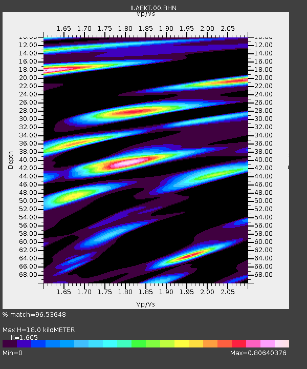
| Estimated Moho Depth: |
18.0 km |
| Estimated Crust Vp/Vs: |
1.61 |
| Assumed Crust Vp: |
6.53 km/s |
| Estimated Crust Vs: |
4.069 km/s |
| Estimated Crust Poisson's Ratio: |
0.18 |
|
| Radial Match: |
96.53648 % |
| Radial Bump: |
400 |
| Transverse Match: |
94.73326 % |
| Transverse Bump: |
400 |
| SOD ConfigId: |
2504 |
| Insert Time: |
2010-03-01 22:45:55.756 +0000 |
| GWidth: |
2.5 |
| Max Bumps: |
400 |
| Tol: |
0.001 |
|

Signal To Noise
| Channel | StoN | STA | LTA |
| II:ABKT:00:BHN:20080911T00:10:48.395007Z | 32.463314 | 1.4857926E-6 | 4.576836E-8 |
| II:ABKT:00:BHE:20080911T00:10:48.395007Z | 11.063591 | 2.6455413E-7 | 2.3912138E-8 |
| II:ABKT:00:BHZ:20080911T00:10:48.395007Z | 20.397629 | 4.794254E-7 | 2.3503977E-8 |
| Arrivals |
| Ps | 1.7 SECOND |
| PpPs | 6.9 SECOND |
| PsPs/PpSs | 8.6 SECOND |


