You are here: Home > Network List > UW - Pacific Northwest Regional Seismic Network Stations List
> Station OMAK Colville Reservation, Omak, WA, USA > Earthquake Result Viewer
OMAK Colville Reservation, Omak, WA, USA - Earthquake Result Viewer
| Earthquake location: |
Off Coast Of Jalisco, Mexico |
| Earthquake latitude/longitude: |
18.9/-107.4 |
| Earthquake time(UTC): |
2014/05/31 (151) 11:53:48 GMT |
| Earthquake Depth: |
10 km |
| Earthquake Magnitude: |
6.2 MWP, 6.6 MI |
| Earthquake Catalog/Contributor: |
NEIC PDE/NEIC COMCAT |
|
| Network: |
UW Pacific Northwest Regional Seismic Network |
| Station: |
OMAK Colville Reservation, Omak, WA, USA |
| Lat/Lon: |
48.36 N/119.33 W |
| Elevation: |
696 m |
|
| Distance: |
31.0 deg |
| Az: |
344.517 deg |
| Baz: |
157.725 deg |
| Ray Param: |
0.07919075 |
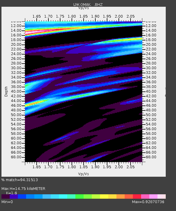
| Estimated Moho Depth: |
14.75 km |
| Estimated Crust Vp/Vs: |
1.60 |
| Assumed Crust Vp: |
6.419 km/s |
| Estimated Crust Vs: |
4.012 km/s |
| Estimated Crust Poisson's Ratio: |
0.18 |
|
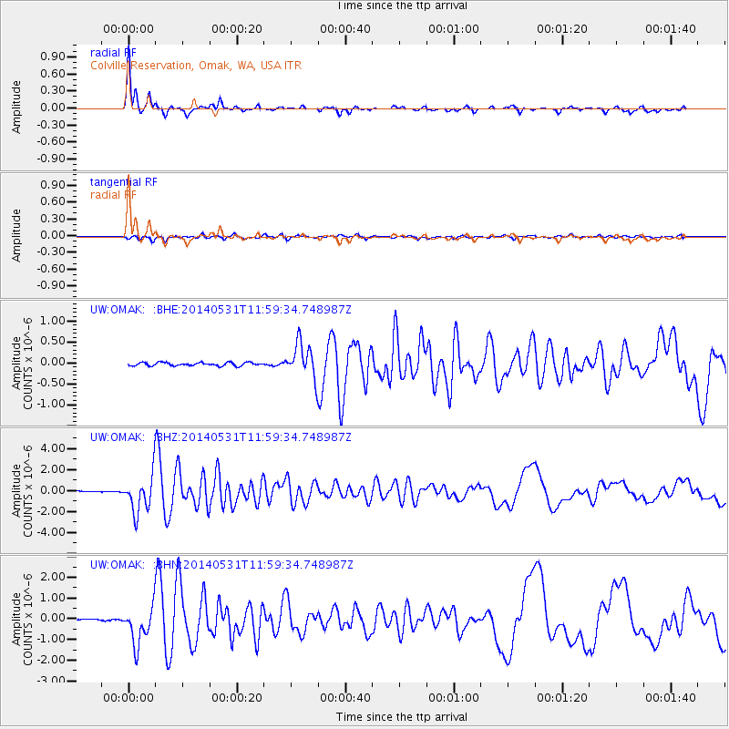
| Radial Match: |
94.31513 % |
| Radial Bump: |
333 |
| Transverse Match: |
83.74 % |
| Transverse Bump: |
400 |
| SOD ConfigId: |
626651 |
| Insert Time: |
2014-06-14 12:45:27.677 +0000 |
| GWidth: |
2.5 |
| Max Bumps: |
400 |
| Tol: |
0.001 |
|
Signal To Noise
| Channel | StoN | STA | LTA |
| UW:OMAK: :BHZ:20140531T11:59:34.748987Z | 33.066334 | 1.8098613E-6 | 5.4734254E-8 |
| UW:OMAK: :BHN:20140531T11:59:34.748987Z | 23.78591 | 9.189053E-7 | 3.8632336E-8 |
| UW:OMAK: :BHE:20140531T11:59:34.748987Z | 10.348714 | 4.0847678E-7 | 3.947126E-8 |
| Arrivals |
| Ps | 1.5 SECOND |
| PpPs | 5.5 SECOND |
| PsPs/PpSs | 7.0 SECOND |


