You are here: Home > Network List > CI - Caltech Regional Seismic Network Stations List
> Station VCS Vincent Substation, Palmdale, CA, USA > Earthquake Result Viewer
VCS Vincent Substation, Palmdale, CA, USA - Earthquake Result Viewer

| Earthquake location: |
East Of Kuril Islands |
| Earthquake latitude/longitude: |
46.2/154.5 |
| Earthquake time(UTC): |
2007/01/13 (013) 04:23:21 GMT |
| Earthquake Depth: |
10 km |
| Earthquake Magnitude: |
7.3 MB, 8.2 MS, 8.1 MW, 7.9 MW |
| Earthquake Catalog/Contributor: |
WHDF/NEIC |
|
| Network: |
CI Caltech Regional Seismic Network |
| Station: |
VCS Vincent Substation, Palmdale, CA, USA |
| Lat/Lon: |
34.48 N/118.12 W |
| Elevation: |
991 m |
|
| Distance: |
64.4 deg |
| Az: |
66.213 deg |
| Baz: |
309.755 deg |
| Ray Param: |
0.058950163 |
| Estimated Moho Depth: |
33.0 km |
| Estimated Crust Vp/Vs: |
1.67 |
| Assumed Crust Vp: |
6.1 km/s |
| Estimated Crust Vs: |
3.653 km/s |
| Estimated Crust Poisson's Ratio: |
0.22 |
|
| Radial Match: |
98.68402 % |
| Radial Bump: |
338 |
| Transverse Match: |
90.039696 % |
| Transverse Bump: |
400 |
| SOD ConfigId: |
2564 |
| Insert Time: |
2010-02-25 21:06:53.898 +0000 |
| GWidth: |
2.5 |
| Max Bumps: |
400 |
| Tol: |
0.001 |
|
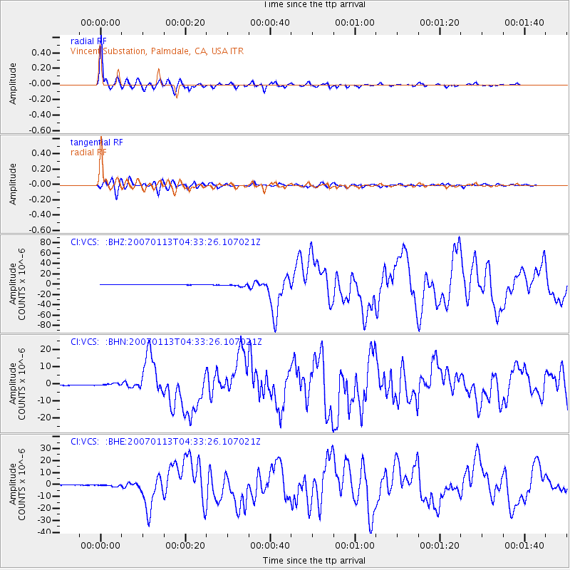
Signal To Noise
| Channel | StoN | STA | LTA |
| CI:VCS: :BHN:20070113T04:33:26.107021Z | 4.950446 | 6.884142E-7 | 1.3906104E-7 |
| CI:VCS: :BHE:20070113T04:33:26.107021Z | 4.636406 | 8.938308E-7 | 1.9278528E-7 |
| CI:VCS: :BHZ:20070113T04:33:26.107021Z | 7.635167 | 2.1969136E-6 | 2.8773613E-7 |
| Arrivals |
| Ps | 3.8 SECOND |
| PpPs | 14 SECOND |
| PsPs/PpSs | 18 SECOND |


