You are here: Home > Network List > TA - USArray Transportable Network (new EarthScope stations) Stations List
> Station G59A Clarenceville, QC, USA > Earthquake Result Viewer
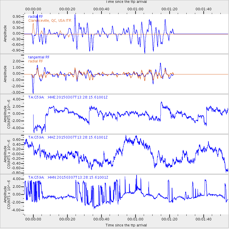
G59A Clarenceville, QC, USA - Earthquake Result Viewer
*The percent match for this event was below the threshold and hence no stack was calculated.
| Earthquake location: |
Andreanof Islands, Aleutian Is. |
| Earthquake latitude/longitude: |
50.5/-173.3 |
| Earthquake time(UTC): |
2015/03/07 (066) 13:18:24 GMT |
| Earthquake Depth: |
10 km |
| Earthquake Magnitude: |
5.7 MO |
| Earthquake Catalog/Contributor: |
NEIC PDE/NEIC ALERT |
|
| Network: |
TA USArray Transportable Network (new EarthScope stations) |
| Station: |
G59A Clarenceville, QC, USA |
| Lat/Lon: |
45.08 N/73.18 W |
| Elevation: |
36 m |
|
| Distance: |
62.4 deg |
| Az: |
51.922 deg |
| Baz: |
314.848 deg |
| Ray Param: |
$rayparam |
*The percent match for this event was below the threshold and hence was not used in the summary stack. |
|
| Radial Match: |
63.45615 % |
| Radial Bump: |
400 |
| Transverse Match: |
79.98923 % |
| Transverse Bump: |
400 |
| SOD ConfigId: |
7019011 |
| Insert Time: |
2019-04-17 05:53:56.023 +0000 |
| GWidth: |
2.5 |
| Max Bumps: |
400 |
| Tol: |
0.001 |
|
Signal To Noise
| Channel | StoN | STA | LTA |
| TA:G59A: :HHZ:20150307T13:28:15.61001Z | 0.60908735 | 6.0776813E-7 | 9.97834E-7 |
| TA:G59A: :HHN:20150307T13:28:15.61001Z | 1.5173789 | 3.1246943E-6 | 2.0592709E-6 |
| TA:G59A: :HHE:20150307T13:28:15.61001Z | 0.7362247 | 1.6765878E-6 | 2.2772772E-6 |
| Arrivals |
| Ps | |
| PpPs | |
| PsPs/PpSs | |


