You are here: Home > Network List > CN - Canadian National Seismograph Network Stations List
> Station INK INUVIK, NT > Earthquake Result Viewer
INK INUVIK, NT - Earthquake Result Viewer
*The percent match for this event was below the threshold and hence no stack was calculated.
| Earthquake location: |
Northern Mid-Atlantic Ridge |
| Earthquake latitude/longitude: |
45.0/-27.8 |
| Earthquake time(UTC): |
2014/05/23 (143) 23:41:49 GMT |
| Earthquake Depth: |
10 km |
| Earthquake Magnitude: |
5.5 MWC, 5.5 MWC |
| Earthquake Catalog/Contributor: |
NEIC PDE/NEIC COMCAT |
|
| Network: |
CN Canadian National Seismograph Network |
| Station: |
INK INUVIK, NT |
| Lat/Lon: |
68.31 N/133.53 W |
| Elevation: |
44 m |
|
| Distance: |
54.3 deg |
| Az: |
333.852 deg |
| Baz: |
57.181 deg |
| Ray Param: |
$rayparam |
*The percent match for this event was below the threshold and hence was not used in the summary stack. |
|
| Radial Match: |
62.423744 % |
| Radial Bump: |
400 |
| Transverse Match: |
74.96711 % |
| Transverse Bump: |
400 |
| SOD ConfigId: |
626651 |
| Insert Time: |
2014-06-15 05:13:39.464 +0000 |
| GWidth: |
2.5 |
| Max Bumps: |
400 |
| Tol: |
0.001 |
|
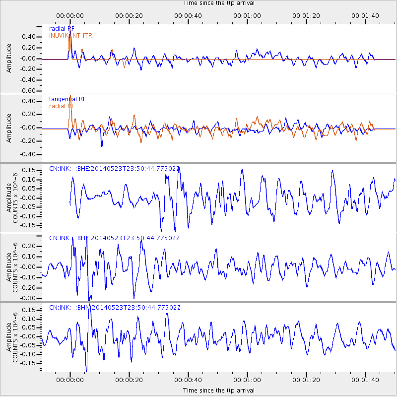
Signal To Noise
| Channel | StoN | STA | LTA |
| CN:INK: :BHZ:20140523T23:50:44.77502Z | 3.1615746 | 1.3250946E-7 | 4.1912486E-8 |
| CN:INK: :BHN:20140523T23:50:44.77502Z | 2.2531343 | 5.966485E-8 | 2.6480823E-8 |
| CN:INK: :BHE:20140523T23:50:44.77502Z | 2.1317143 | 8.7183714E-8 | 4.0898403E-8 |
| Arrivals |
| Ps | |
| PpPs | |
| PsPs/PpSs | |


