You are here: Home > Network List > TA - USArray Transportable Network (new EarthScope stations) Stations List
> Station O48A Farmland, IN, USA > Earthquake Result Viewer
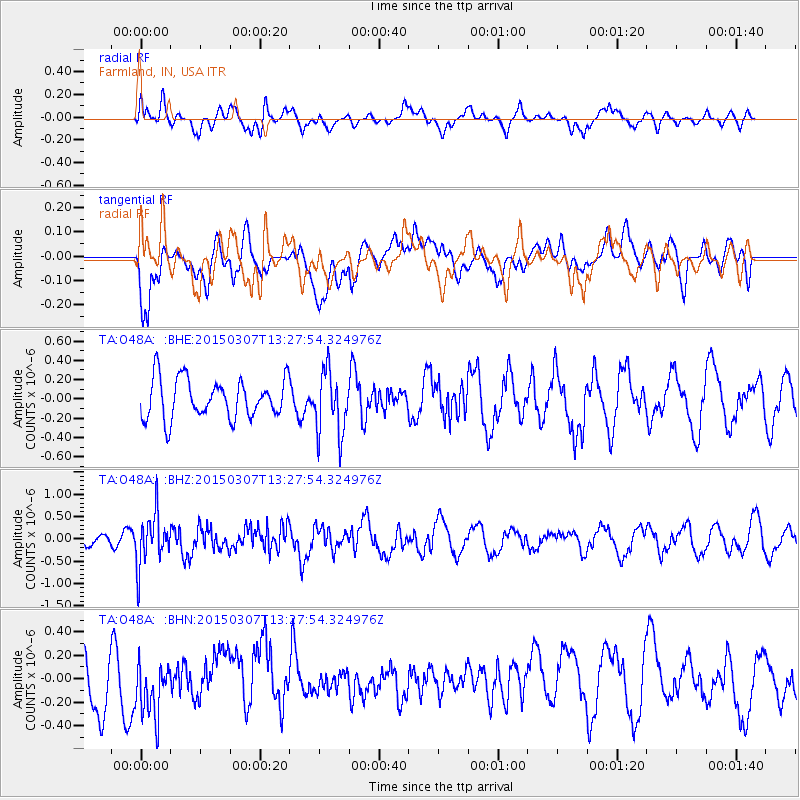
O48A Farmland, IN, USA - Earthquake Result Viewer
*The percent match for this event was below the threshold and hence no stack was calculated.
| Earthquake location: |
Andreanof Islands, Aleutian Is. |
| Earthquake latitude/longitude: |
50.5/-173.3 |
| Earthquake time(UTC): |
2015/03/07 (066) 13:18:24 GMT |
| Earthquake Depth: |
10 km |
| Earthquake Magnitude: |
5.7 MO |
| Earthquake Catalog/Contributor: |
NEIC PDE/NEIC ALERT |
|
| Network: |
TA USArray Transportable Network (new EarthScope stations) |
| Station: |
O48A Farmland, IN, USA |
| Lat/Lon: |
40.26 N/85.16 W |
| Elevation: |
300 m |
|
| Distance: |
59.3 deg |
| Az: |
62.869 deg |
| Baz: |
312.091 deg |
| Ray Param: |
$rayparam |
*The percent match for this event was below the threshold and hence was not used in the summary stack. |
|
| Radial Match: |
37.91914 % |
| Radial Bump: |
400 |
| Transverse Match: |
58.55661 % |
| Transverse Bump: |
400 |
| SOD ConfigId: |
7019011 |
| Insert Time: |
2019-04-17 05:55:00.371 +0000 |
| GWidth: |
2.5 |
| Max Bumps: |
400 |
| Tol: |
0.001 |
|
Signal To Noise
| Channel | StoN | STA | LTA |
| TA:O48A: :BHZ:20150307T13:27:54.324976Z | 3.5894377 | 5.6584173E-7 | 1.5764077E-7 |
| TA:O48A: :BHN:20150307T13:27:54.324976Z | 1.2940038 | 2.3002556E-7 | 1.7776266E-7 |
| TA:O48A: :BHE:20150307T13:27:54.324976Z | 1.6338673 | 3.3303692E-7 | 2.0383354E-7 |
| Arrivals |
| Ps | |
| PpPs | |
| PsPs/PpSs | |


