You are here: Home > Network List > TA - USArray Transportable Network (new EarthScope stations) Stations List
> Station R11A Troy Canyon, Currant, NV, USA > Earthquake Result Viewer
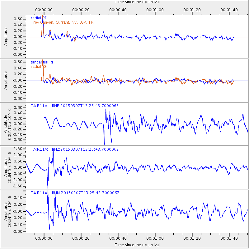
R11A Troy Canyon, Currant, NV, USA - Earthquake Result Viewer
*The percent match for this event was below the threshold and hence no stack was calculated.
| Earthquake location: |
Andreanof Islands, Aleutian Is. |
| Earthquake latitude/longitude: |
50.5/-173.3 |
| Earthquake time(UTC): |
2015/03/07 (066) 13:18:24 GMT |
| Earthquake Depth: |
10 km |
| Earthquake Magnitude: |
5.7 MO |
| Earthquake Catalog/Contributor: |
NEIC PDE/NEIC ALERT |
|
| Network: |
TA USArray Transportable Network (new EarthScope stations) |
| Station: |
R11A Troy Canyon, Currant, NV, USA |
| Lat/Lon: |
38.35 N/115.59 W |
| Elevation: |
1756 m |
|
| Distance: |
42.0 deg |
| Az: |
83.892 deg |
| Baz: |
306.199 deg |
| Ray Param: |
$rayparam |
*The percent match for this event was below the threshold and hence was not used in the summary stack. |
|
| Radial Match: |
71.250404 % |
| Radial Bump: |
400 |
| Transverse Match: |
46.166687 % |
| Transverse Bump: |
400 |
| SOD ConfigId: |
7019011 |
| Insert Time: |
2019-04-17 05:55:15.883 +0000 |
| GWidth: |
2.5 |
| Max Bumps: |
400 |
| Tol: |
0.001 |
|
Signal To Noise
| Channel | StoN | STA | LTA |
| TA:R11A: :BHZ:20150307T13:25:43.700006Z | 3.050885 | 5.740163E-7 | 1.8814748E-7 |
| TA:R11A: :BHN:20150307T13:25:43.700006Z | 2.4593143 | 2.477667E-7 | 1.0074626E-7 |
| TA:R11A: :BHE:20150307T13:25:43.700006Z | 2.2239163 | 2.599596E-7 | 1.1689271E-7 |
| Arrivals |
| Ps | |
| PpPs | |
| PsPs/PpSs | |


