You are here: Home > Network List > II - Global Seismograph Network (GSN - IRIS/IDA) Stations List
> Station ABKT Alibek, Turkmenistan > Earthquake Result Viewer
ABKT Alibek, Turkmenistan - Earthquake Result Viewer
| Earthquake location: |
Mariana Islands |
| Earthquake latitude/longitude: |
15.7/146.6 |
| Earthquake time(UTC): |
1993/06/06 (157) 13:23:27 GMT |
| Earthquake Depth: |
68 km |
| Earthquake Magnitude: |
5.8 MB, 6.4 UNKNOWN |
| Earthquake Catalog/Contributor: |
WHDF/NEIC |
|
| Network: |
II Global Seismograph Network (GSN - IRIS/IDA) |
| Station: |
ABKT Alibek, Turkmenistan |
| Lat/Lon: |
37.93 N/58.12 E |
| Elevation: |
678 m |
|
| Distance: |
79.3 deg |
| Az: |
306.453 deg |
| Baz: |
78.466 deg |
| Ray Param: |
0.048887428 |
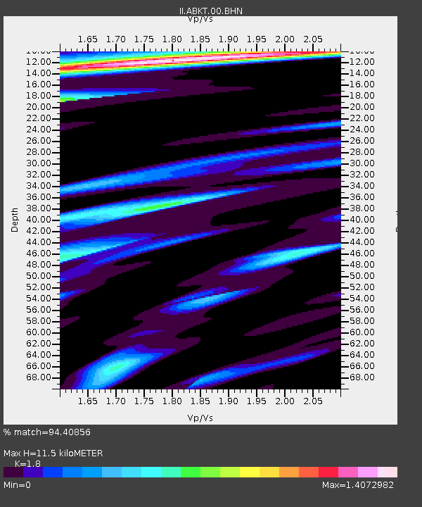
| Estimated Moho Depth: |
11.5 km |
| Estimated Crust Vp/Vs: |
1.80 |
| Assumed Crust Vp: |
6.53 km/s |
| Estimated Crust Vs: |
3.628 km/s |
| Estimated Crust Poisson's Ratio: |
0.28 |
|
| Radial Match: |
94.40856 % |
| Radial Bump: |
400 |
| Transverse Match: |
85.50541 % |
| Transverse Bump: |
400 |
| SOD ConfigId: |
61242 |
| Insert Time: |
2010-03-01 22:46:36.525 +0000 |
| GWidth: |
2.5 |
| Max Bumps: |
400 |
| Tol: |
0.001 |
|

Signal To Noise
| Channel | StoN | STA | LTA |
| II:ABKT:00:BHN:19930606T13:34:54.893005Z | 3.732886 | 1.6228724E-7 | 4.3475E-8 |
| II:ABKT:00:BHE:19930606T13:34:54.893005Z | 22.183802 | 6.951708E-7 | 3.1336867E-8 |
| II:ABKT:00:BHZ:19930606T13:34:54.893005Z | 40.42949 | 2.2362083E-6 | 5.5311318E-8 |
| Arrivals |
| Ps | 1.5 SECOND |
| PpPs | 4.8 SECOND |
| PsPs/PpSs | 6.2 SECOND |


