You are here: Home > Network List > TA - USArray Transportable Network (new EarthScope stations) Stations List
> Station T57A Hurt, VA, USA > Earthquake Result Viewer
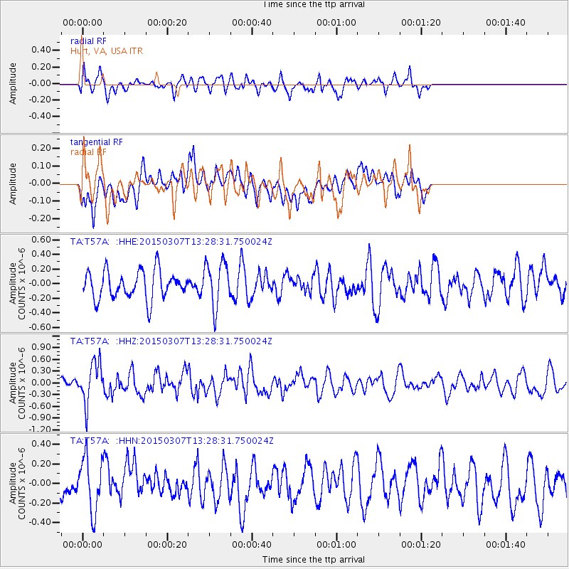
T57A Hurt, VA, USA - Earthquake Result Viewer
*The percent match for this event was below the threshold and hence no stack was calculated.
| Earthquake location: |
Andreanof Islands, Aleutian Is. |
| Earthquake latitude/longitude: |
50.5/-173.3 |
| Earthquake time(UTC): |
2015/03/07 (066) 13:18:24 GMT |
| Earthquake Depth: |
10 km |
| Earthquake Magnitude: |
5.7 MO |
| Earthquake Catalog/Contributor: |
NEIC PDE/NEIC ALERT |
|
| Network: |
TA USArray Transportable Network (new EarthScope stations) |
| Station: |
T57A Hurt, VA, USA |
| Lat/Lon: |
37.00 N/79.25 W |
| Elevation: |
230 m |
|
| Distance: |
64.8 deg |
| Az: |
61.915 deg |
| Baz: |
315.315 deg |
| Ray Param: |
$rayparam |
*The percent match for this event was below the threshold and hence was not used in the summary stack. |
|
| Radial Match: |
64.4592 % |
| Radial Bump: |
400 |
| Transverse Match: |
41.64228 % |
| Transverse Bump: |
400 |
| SOD ConfigId: |
7019011 |
| Insert Time: |
2019-04-17 05:55:26.592 +0000 |
| GWidth: |
2.5 |
| Max Bumps: |
400 |
| Tol: |
0.001 |
|
Signal To Noise
| Channel | StoN | STA | LTA |
| TA:T57A: :HHZ:20150307T13:28:31.750024Z | 2.9541051 | 5.253548E-7 | 1.7783888E-7 |
| TA:T57A: :HHN:20150307T13:28:31.750024Z | 2.1293468 | 2.8438706E-7 | 1.33556E-7 |
| TA:T57A: :HHE:20150307T13:28:31.750024Z | 1.6328484 | 3.0677973E-7 | 1.878801E-7 |
| Arrivals |
| Ps | |
| PpPs | |
| PsPs/PpSs | |


