You are here: Home > Network List > II - Global Seismograph Network (GSN - IRIS/IDA) Stations List
> Station ABKT Alibek, Turkmenistan > Earthquake Result Viewer
ABKT Alibek, Turkmenistan - Earthquake Result Viewer
| Earthquake location: |
Near East Coast Of Kamchatka |
| Earthquake latitude/longitude: |
51.2/157.8 |
| Earthquake time(UTC): |
1993/06/08 (159) 13:03:37 GMT |
| Earthquake Depth: |
81 km |
| Earthquake Magnitude: |
6.4 MB, 7.3 MS |
| Earthquake Catalog/Contributor: |
WHDF/NEIC |
|
| Network: |
II Global Seismograph Network (GSN - IRIS/IDA) |
| Station: |
ABKT Alibek, Turkmenistan |
| Lat/Lon: |
37.93 N/58.12 E |
| Elevation: |
678 m |
|
| Distance: |
66.9 deg |
| Az: |
302.09 deg |
| Baz: |
42.361 deg |
| Ray Param: |
0.057094496 |
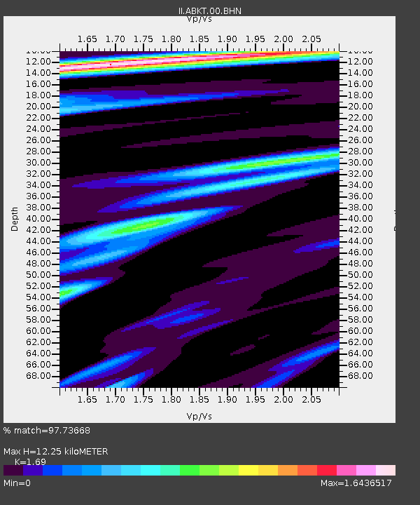
| Estimated Moho Depth: |
12.25 km |
| Estimated Crust Vp/Vs: |
1.69 |
| Assumed Crust Vp: |
6.53 km/s |
| Estimated Crust Vs: |
3.864 km/s |
| Estimated Crust Poisson's Ratio: |
0.23 |
|
| Radial Match: |
97.73668 % |
| Radial Bump: |
400 |
| Transverse Match: |
84.57432 % |
| Transverse Bump: |
400 |
| SOD ConfigId: |
61242 |
| Insert Time: |
2010-03-01 22:46:38.265 +0000 |
| GWidth: |
2.5 |
| Max Bumps: |
400 |
| Tol: |
0.001 |
|
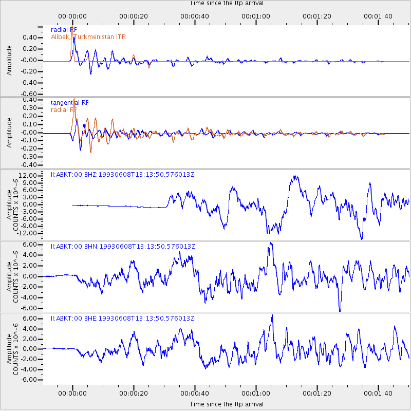
Signal To Noise
| Channel | StoN | STA | LTA |
| II:ABKT:00:BHN:19930608T13:13:50.576013Z | 8.201085 | 7.3355426E-7 | 8.9446E-8 |
| II:ABKT:00:BHE:19930608T13:13:50.576013Z | 4.9887843 | 6.7543135E-7 | 1.3538997E-7 |
| II:ABKT:00:BHZ:19930608T13:13:50.576013Z | 11.873552 | 2.8197182E-6 | 2.3747891E-7 |
| Arrivals |
| Ps | 1.4 SECOND |
| PpPs | 4.8 SECOND |
| PsPs/PpSs | 6.2 SECOND |


