You are here: Home > Network List > N4 - Central and EAstern US Network Stations List
> Station E43A Lone Tree Farm, Eben Junction, MI, USA > Earthquake Result Viewer
E43A Lone Tree Farm, Eben Junction, MI, USA - Earthquake Result Viewer
| Earthquake location: |
Northern Mid-Atlantic Ridge |
| Earthquake latitude/longitude: |
45.0/-27.8 |
| Earthquake time(UTC): |
2014/05/23 (143) 23:41:49 GMT |
| Earthquake Depth: |
10 km |
| Earthquake Magnitude: |
5.5 MWC, 5.5 MWC |
| Earthquake Catalog/Contributor: |
NEIC PDE/NEIC COMCAT |
|
| Network: |
N4 Central and EAstern US Network |
| Station: |
E43A Lone Tree Farm, Eben Junction, MI, USA |
| Lat/Lon: |
46.38 N/87.00 W |
| Elevation: |
303 m |
|
| Distance: |
40.5 deg |
| Az: |
293.727 deg |
| Baz: |
69.631 deg |
| Ray Param: |
0.07437018 |
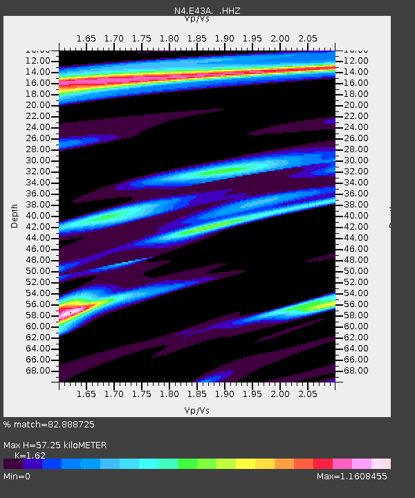
| Estimated Moho Depth: |
57.25 km |
| Estimated Crust Vp/Vs: |
1.62 |
| Assumed Crust Vp: |
6.472 km/s |
| Estimated Crust Vs: |
3.995 km/s |
| Estimated Crust Poisson's Ratio: |
0.19 |
|
| Radial Match: |
82.888725 % |
| Radial Bump: |
400 |
| Transverse Match: |
54.644676 % |
| Transverse Bump: |
400 |
| SOD ConfigId: |
626651 |
| Insert Time: |
2014-06-15 05:24:02.258 +0000 |
| GWidth: |
2.5 |
| Max Bumps: |
400 |
| Tol: |
0.001 |
|

Signal To Noise
| Channel | StoN | STA | LTA |
| N4:E43A: :HHZ:20140523T23:48:57.420009Z | 3.0560493 | 1.5492664E-7 | 5.069507E-8 |
| N4:E43A: :HHN:20140523T23:48:57.420009Z | 0.6947651 | 3.9012438E-8 | 5.6151986E-8 |
| N4:E43A: :HHE:20140523T23:48:57.420009Z | 1.5867616 | 7.6996756E-8 | 4.8524463E-8 |
| Arrivals |
| Ps | 5.9 SECOND |
| PpPs | 21 SECOND |
| PsPs/PpSs | 27 SECOND |


