You are here: Home > Network List > II - Global Seismograph Network (GSN - IRIS/IDA) Stations List
> Station ABKT Alibek, Turkmenistan > Earthquake Result Viewer
ABKT Alibek, Turkmenistan - Earthquake Result Viewer
| Earthquake location: |
Northeast Of Taiwan |
| Earthquake latitude/longitude: |
26.5/125.6 |
| Earthquake time(UTC): |
1993/08/07 (219) 00:00:37 GMT |
| Earthquake Depth: |
158 km |
| Earthquake Magnitude: |
6.0 MB, 6.4 UNKNOWN, 6.4 MW |
| Earthquake Catalog/Contributor: |
WHDF/NEIC |
|
| Network: |
II Global Seismograph Network (GSN - IRIS/IDA) |
| Station: |
ABKT Alibek, Turkmenistan |
| Lat/Lon: |
37.93 N/58.12 E |
| Elevation: |
678 m |
|
| Distance: |
57.1 deg |
| Az: |
299.544 deg |
| Baz: |
80.321 deg |
| Ray Param: |
0.06320571 |
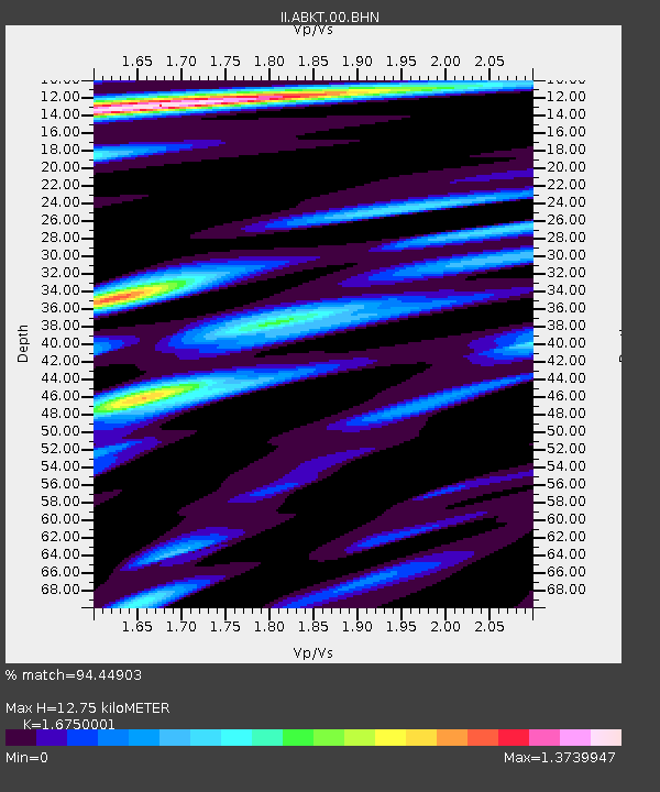
| Estimated Moho Depth: |
12.75 km |
| Estimated Crust Vp/Vs: |
1.68 |
| Assumed Crust Vp: |
6.53 km/s |
| Estimated Crust Vs: |
3.899 km/s |
| Estimated Crust Poisson's Ratio: |
0.22 |
|
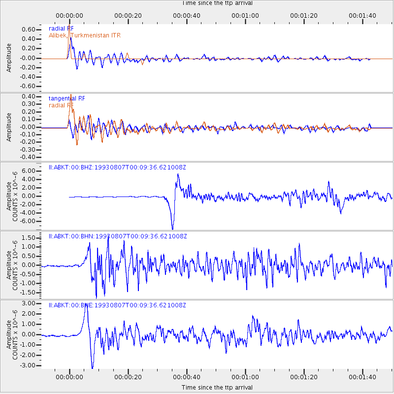
| Radial Match: |
94.44903 % |
| Radial Bump: |
400 |
| Transverse Match: |
84.57554 % |
| Transverse Bump: |
400 |
| SOD ConfigId: |
61242 |
| Insert Time: |
2010-03-01 22:46:46.303 +0000 |
| GWidth: |
2.5 |
| Max Bumps: |
400 |
| Tol: |
0.001 |
|
Signal To Noise
| Channel | StoN | STA | LTA |
| II:ABKT:00:BHN:19930807T00:09:36.621008Z | 1.9141142 | 5.813483E-8 | 3.0371663E-8 |
| II:ABKT:00:BHE:19930807T00:09:36.621008Z | 12.101795 | 4.5133567E-7 | 3.7294935E-8 |
| II:ABKT:00:BHZ:19930807T00:09:36.621008Z | 27.056808 | 1.5213565E-6 | 5.6228235E-8 |
| Arrivals |
| Ps | 1.4 SECOND |
| PpPs | 4.9 SECOND |
| PsPs/PpSs | 6.3 SECOND |


