ABKT Alibek, Turkmenistan - Earthquake Result Viewer
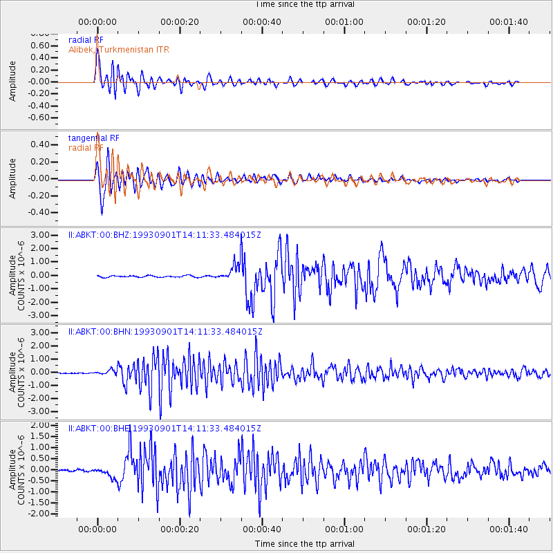
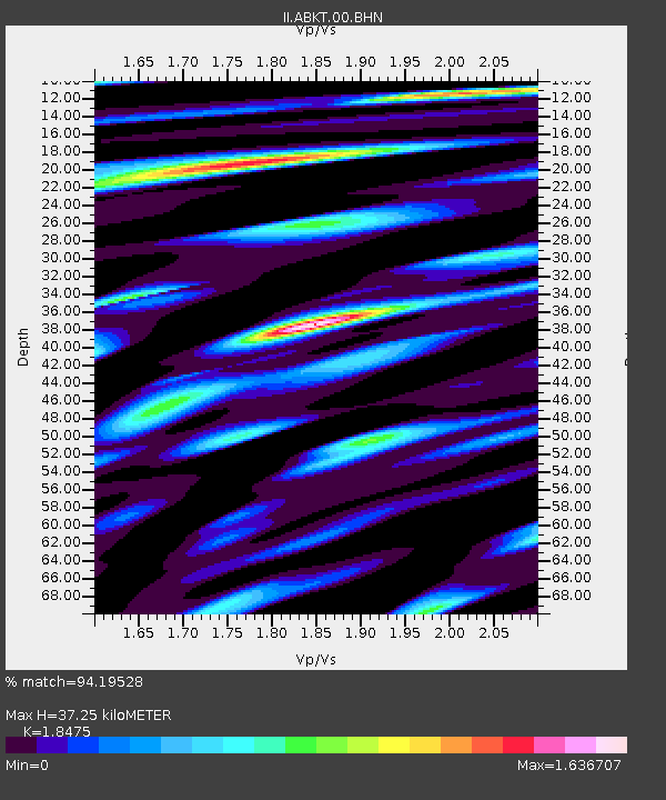
Earthquake location: Northern Sumatra, Indonesia
Earthquake latitude/longitude: 2.9/96.2
Earthquake time(UTC): 1993/09/01 (244) 14:03:18 GMT
Earthquake Depth: 33 km
Earthquake Magnitude: 5.8 MB, 6.2 MS, 6.0 UNKNOWN, 6.2 MW
Earthquake Catalog/Contributor: WHDF/NEIC
Network: II Global Seismograph Network (GSN - IRIS/IDA)
Station: ABKT Alibek, Turkmenistan
Lat/Lon: 37.93 N/58.12 E
Elevation: 678 m
Distance: 49.2 deg
Az: 319.947 deg
Baz: 125.638 deg
Ray Param: 0.068777055
Estimated Moho Depth: 37.25 km
Estimated Crust Vp/Vs: 1.85
Assumed Crust Vp: 6.53 km/s
Estimated Crust Vs: 3.535 km/s
Estimated Crust Poisson's Ratio: 0.29
Radial Match: 94.19528 %
Radial Bump: 400
Transverse Match: 93.870415 %
Transverse Bump: 400
SOD ConfigId: 61242
Insert Time: 2010-03-01 22:46:54.344 +0000
GWidth: 2.5
Max Bumps: 400
Tol: 0.001

Signal To Noise

ChannelStoNSTALTA
II:ABKT:00:BHN:19930901T14:11:33.484015Z6.65417241.8463633E-72.774745E-8
II:ABKT:00:BHE:19930901T14:11:33.484015Z6.8202112.408389E-73.5312528E-8
II:ABKT:00:BHZ:19930901T14:11:33.484015Z11.1573046.5094537E-75.8342533E-8
Arrivals
Ps5.1 SECOND
PpPs15 SECOND
PsPs/PpSs20 SECOND