You are here: Home > Network List > N4 - Central and EAstern US Network Stations List
> Station R49A Shelbyville, KY, USA > Earthquake Result Viewer
R49A Shelbyville, KY, USA - Earthquake Result Viewer
| Earthquake location: |
Northern Mid-Atlantic Ridge |
| Earthquake latitude/longitude: |
45.0/-27.8 |
| Earthquake time(UTC): |
2014/05/23 (143) 23:41:49 GMT |
| Earthquake Depth: |
10 km |
| Earthquake Magnitude: |
5.5 MWC, 5.5 MWC |
| Earthquake Catalog/Contributor: |
NEIC PDE/NEIC COMCAT |
|
| Network: |
N4 Central and EAstern US Network |
| Station: |
R49A Shelbyville, KY, USA |
| Lat/Lon: |
38.29 N/85.17 W |
| Elevation: |
251 m |
|
| Distance: |
42.6 deg |
| Az: |
281.77 deg |
| Baz: |
61.892 deg |
| Ray Param: |
0.07309033 |
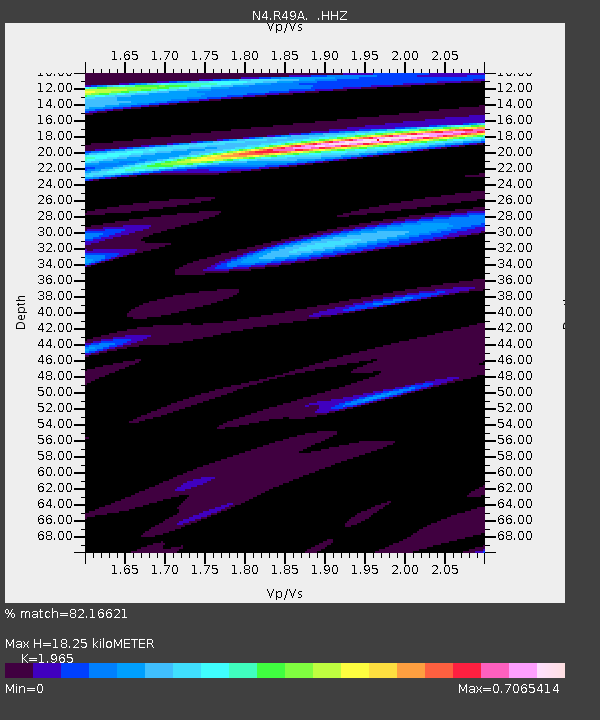
| Estimated Moho Depth: |
18.25 km |
| Estimated Crust Vp/Vs: |
1.97 |
| Assumed Crust Vp: |
6.498 km/s |
| Estimated Crust Vs: |
3.307 km/s |
| Estimated Crust Poisson's Ratio: |
0.33 |
|
| Radial Match: |
82.16621 % |
| Radial Bump: |
365 |
| Transverse Match: |
52.247593 % |
| Transverse Bump: |
342 |
| SOD ConfigId: |
626651 |
| Insert Time: |
2014-06-15 05:26:52.794 +0000 |
| GWidth: |
2.5 |
| Max Bumps: |
400 |
| Tol: |
0.001 |
|

Signal To Noise
| Channel | StoN | STA | LTA |
| N4:R49A: :HHZ:20140523T23:49:14.550013Z | 5.554484 | 3.348194E-7 | 6.027912E-8 |
| N4:R49A: :HHN:20140523T23:49:14.550013Z | 2.249202 | 8.595615E-8 | 3.821629E-8 |
| N4:R49A: :HHE:20140523T23:49:14.550013Z | 3.385879 | 1.3721586E-7 | 4.052592E-8 |
| Arrivals |
| Ps | 2.9 SECOND |
| PpPs | 7.8 SECOND |
| PsPs/PpSs | 11 SECOND |


