You are here: Home > Network List > TA - USArray Transportable Network (new EarthScope stations) Stations List
> Station D49A Beulah Township, ON, CAN > Earthquake Result Viewer
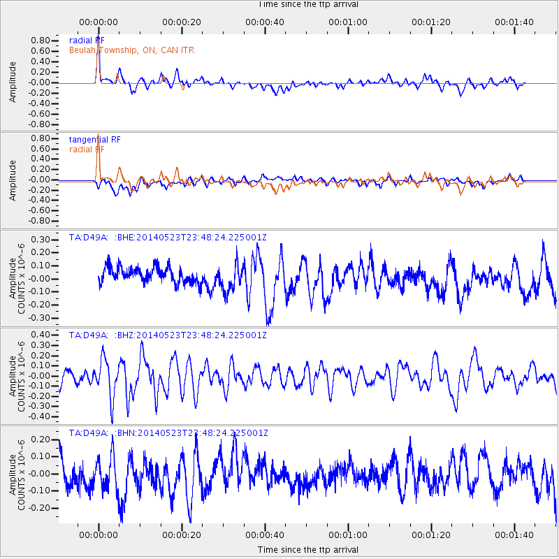
D49A Beulah Township, ON, CAN - Earthquake Result Viewer
*The percent match for this event was below the threshold and hence no stack was calculated.
| Earthquake location: |
Northern Mid-Atlantic Ridge |
| Earthquake latitude/longitude: |
45.0/-27.8 |
| Earthquake time(UTC): |
2014/05/23 (143) 23:41:49 GMT |
| Earthquake Depth: |
10 km |
| Earthquake Magnitude: |
5.5 MWC, 5.5 MWC |
| Earthquake Catalog/Contributor: |
NEIC PDE/NEIC COMCAT |
|
| Network: |
TA USArray Transportable Network (new EarthScope stations) |
| Station: |
D49A Beulah Township, ON, CAN |
| Lat/Lon: |
47.27 N/81.36 W |
| Elevation: |
416 m |
|
| Distance: |
36.5 deg |
| Az: |
293.113 deg |
| Baz: |
73.251 deg |
| Ray Param: |
$rayparam |
*The percent match for this event was below the threshold and hence was not used in the summary stack. |
|
| Radial Match: |
58.35537 % |
| Radial Bump: |
400 |
| Transverse Match: |
47.01742 % |
| Transverse Bump: |
400 |
| SOD ConfigId: |
626651 |
| Insert Time: |
2014-06-15 05:32:33.628 +0000 |
| GWidth: |
2.5 |
| Max Bumps: |
400 |
| Tol: |
0.001 |
|
Signal To Noise
| Channel | StoN | STA | LTA |
| TA:D49A: :BHZ:20140523T23:48:24.225001Z | 2.897054 | 1.8827423E-7 | 6.4988164E-8 |
| TA:D49A: :BHN:20140523T23:48:24.225001Z | 1.1856612 | 1.0753036E-7 | 9.069232E-8 |
| TA:D49A: :BHE:20140523T23:48:24.225001Z | 1.8243728 | 1.0789064E-7 | 5.9138483E-8 |
| Arrivals |
| Ps | |
| PpPs | |
| PsPs/PpSs | |


