You are here: Home > Network List > UW - Pacific Northwest Regional Seismic Network Stations List
> Station UMAT Pilot Rock, OR, USA > Earthquake Result Viewer
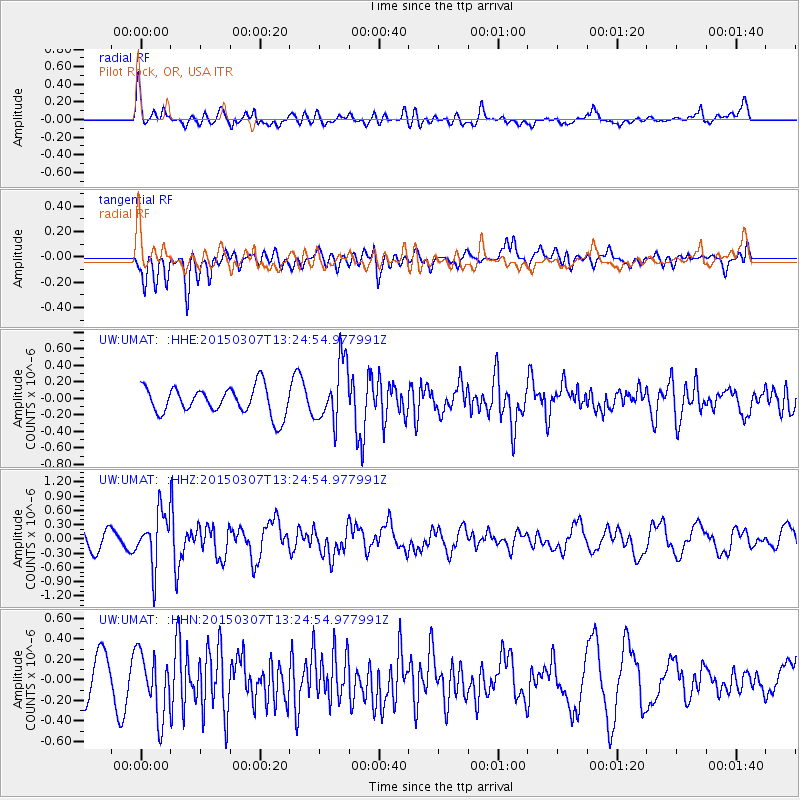
UMAT Pilot Rock, OR, USA - Earthquake Result Viewer
*The percent match for this event was below the threshold and hence no stack was calculated.
| Earthquake location: |
Andreanof Islands, Aleutian Is. |
| Earthquake latitude/longitude: |
50.5/-173.3 |
| Earthquake time(UTC): |
2015/03/07 (066) 13:18:24 GMT |
| Earthquake Depth: |
10 km |
| Earthquake Magnitude: |
5.7 MO |
| Earthquake Catalog/Contributor: |
NEIC PDE/NEIC ALERT |
|
| Network: |
UW Pacific Northwest Regional Seismic Network |
| Station: |
UMAT Pilot Rock, OR, USA |
| Lat/Lon: |
45.29 N/118.96 W |
| Elevation: |
1318 m |
|
| Distance: |
36.1 deg |
| Az: |
76.726 deg |
| Baz: |
298.378 deg |
| Ray Param: |
$rayparam |
*The percent match for this event was below the threshold and hence was not used in the summary stack. |
|
| Radial Match: |
52.77159 % |
| Radial Bump: |
400 |
| Transverse Match: |
54.704185 % |
| Transverse Bump: |
400 |
| SOD ConfigId: |
7019011 |
| Insert Time: |
2019-04-17 05:56:56.880 +0000 |
| GWidth: |
2.5 |
| Max Bumps: |
400 |
| Tol: |
0.001 |
|
Signal To Noise
| Channel | StoN | STA | LTA |
| UW:UMAT: :HHZ:20150307T13:24:54.977991Z | 2.876111 | 5.629382E-7 | 1.9572897E-7 |
| UW:UMAT: :HHN:20150307T13:24:54.977991Z | 1.6681714 | 3.0694096E-7 | 1.8399844E-7 |
| UW:UMAT: :HHE:20150307T13:24:54.977991Z | 2.2139595 | 3.672269E-7 | 1.6586884E-7 |
| Arrivals |
| Ps | |
| PpPs | |
| PsPs/PpSs | |


