You are here: Home > Network List > TA - USArray Transportable Network (new EarthScope stations) Stations List
> Station J47A Sunmer, MI, USA > Earthquake Result Viewer
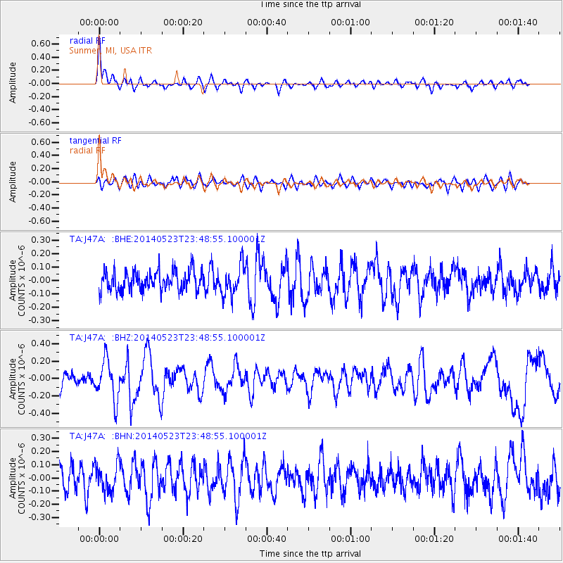
J47A Sunmer, MI, USA - Earthquake Result Viewer
*The percent match for this event was below the threshold and hence no stack was calculated.
| Earthquake location: |
Northern Mid-Atlantic Ridge |
| Earthquake latitude/longitude: |
45.0/-27.8 |
| Earthquake time(UTC): |
2014/05/23 (143) 23:41:49 GMT |
| Earthquake Depth: |
10 km |
| Earthquake Magnitude: |
5.5 MWC, 5.5 MWC |
| Earthquake Catalog/Contributor: |
NEIC PDE/NEIC COMCAT |
|
| Network: |
TA USArray Transportable Network (new EarthScope stations) |
| Station: |
J47A Sunmer, MI, USA |
| Lat/Lon: |
43.24 N/84.82 W |
| Elevation: |
236 m |
|
| Distance: |
40.2 deg |
| Az: |
288.341 deg |
| Baz: |
67.052 deg |
| Ray Param: |
$rayparam |
*The percent match for this event was below the threshold and hence was not used in the summary stack. |
|
| Radial Match: |
69.111534 % |
| Radial Bump: |
400 |
| Transverse Match: |
50.66961 % |
| Transverse Bump: |
400 |
| SOD ConfigId: |
626651 |
| Insert Time: |
2014-06-15 05:37:10.270 +0000 |
| GWidth: |
2.5 |
| Max Bumps: |
400 |
| Tol: |
0.001 |
|
Signal To Noise
| Channel | StoN | STA | LTA |
| TA:J47A: :BHZ:20140523T23:48:55.100001Z | 3.469072 | 2.316657E-7 | 6.678031E-8 |
| TA:J47A: :BHN:20140523T23:48:55.100001Z | 1.0194153 | 1.02781634E-7 | 1.008241E-7 |
| TA:J47A: :BHE:20140523T23:48:55.100001Z | 1.5452553 | 1.1140427E-7 | 7.209441E-8 |
| Arrivals |
| Ps | |
| PpPs | |
| PsPs/PpSs | |


