You are here: Home > Network List > TA - USArray Transportable Network (new EarthScope stations) Stations List
> Station N54A Moraine State Park, Portersville, PA, USA > Earthquake Result Viewer
N54A Moraine State Park, Portersville, PA, USA - Earthquake Result Viewer
| Earthquake location: |
Northern Mid-Atlantic Ridge |
| Earthquake latitude/longitude: |
45.0/-27.8 |
| Earthquake time(UTC): |
2014/05/23 (143) 23:41:49 GMT |
| Earthquake Depth: |
10 km |
| Earthquake Magnitude: |
5.5 MWC, 5.5 MWC |
| Earthquake Catalog/Contributor: |
NEIC PDE/NEIC COMCAT |
|
| Network: |
TA USArray Transportable Network (new EarthScope stations) |
| Station: |
N54A Moraine State Park, Portersville, PA, USA |
| Lat/Lon: |
40.96 N/79.99 W |
| Elevation: |
408 m |
|
| Distance: |
37.8 deg |
| Az: |
282.75 deg |
| Baz: |
65.936 deg |
| Ray Param: |
0.07592051 |
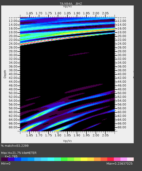
| Estimated Moho Depth: |
21.75 km |
| Estimated Crust Vp/Vs: |
1.76 |
| Assumed Crust Vp: |
6.121 km/s |
| Estimated Crust Vs: |
3.468 km/s |
| Estimated Crust Poisson's Ratio: |
0.26 |
|
| Radial Match: |
83.2299 % |
| Radial Bump: |
400 |
| Transverse Match: |
44.945705 % |
| Transverse Bump: |
400 |
| SOD ConfigId: |
626651 |
| Insert Time: |
2014-06-15 05:40:30.002 +0000 |
| GWidth: |
2.5 |
| Max Bumps: |
400 |
| Tol: |
0.001 |
|
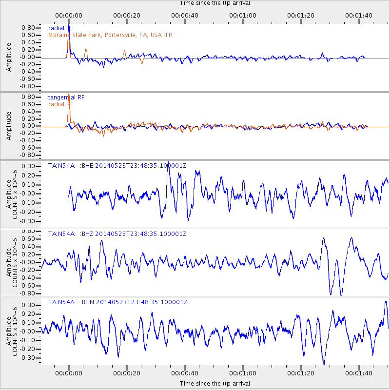
Signal To Noise
| Channel | StoN | STA | LTA |
| TA:N54A: :BHZ:20140523T23:48:35.100001Z | 2.5704904 | 2.1811721E-7 | 8.4854314E-8 |
| TA:N54A: :BHN:20140523T23:48:35.100001Z | 1.2705035 | 9.103082E-8 | 7.16494E-8 |
| TA:N54A: :BHE:20140523T23:48:35.100001Z | 3.2062006 | 1.7203601E-7 | 5.365728E-8 |
| Arrivals |
| Ps | 2.9 SECOND |
| PpPs | 9.2 SECOND |
| PsPs/PpSs | 12 SECOND |


