You are here: Home > Network List > TA - USArray Transportable Network (new EarthScope stations) Stations List
> Station O50A Cable, OH, USA > Earthquake Result Viewer
O50A Cable, OH, USA - Earthquake Result Viewer
| Earthquake location: |
Northern Mid-Atlantic Ridge |
| Earthquake latitude/longitude: |
45.0/-27.8 |
| Earthquake time(UTC): |
2014/05/23 (143) 23:41:49 GMT |
| Earthquake Depth: |
10 km |
| Earthquake Magnitude: |
5.5 MWC, 5.5 MWC |
| Earthquake Catalog/Contributor: |
NEIC PDE/NEIC COMCAT |
|
| Network: |
TA USArray Transportable Network (new EarthScope stations) |
| Station: |
O50A Cable, OH, USA |
| Lat/Lon: |
40.15 N/83.62 W |
| Elevation: |
399 m |
|
| Distance: |
40.7 deg |
| Az: |
283.431 deg |
| Baz: |
64.111 deg |
| Ray Param: |
0.07426569 |
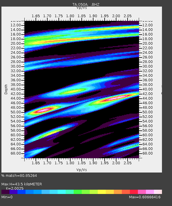
| Estimated Moho Depth: |
43.5 km |
| Estimated Crust Vp/Vs: |
2.00 |
| Assumed Crust Vp: |
6.498 km/s |
| Estimated Crust Vs: |
3.245 km/s |
| Estimated Crust Poisson's Ratio: |
0.33 |
|
| Radial Match: |
80.85264 % |
| Radial Bump: |
400 |
| Transverse Match: |
46.870834 % |
| Transverse Bump: |
400 |
| SOD ConfigId: |
626651 |
| Insert Time: |
2014-06-15 05:41:07.284 +0000 |
| GWidth: |
2.5 |
| Max Bumps: |
400 |
| Tol: |
0.001 |
|

Signal To Noise
| Channel | StoN | STA | LTA |
| TA:O50A: :BHZ:20140523T23:48:58.874995Z | 4.737751 | 2.6372538E-7 | 5.5664675E-8 |
| TA:O50A: :BHN:20140523T23:48:58.874995Z | 2.2723463 | 1.0708204E-7 | 4.7123997E-8 |
| TA:O50A: :BHE:20140523T23:48:58.874995Z | 3.509835 | 1.9875132E-7 | 5.662697E-8 |
| Arrivals |
| Ps | 7.1 SECOND |
| PpPs | 19 SECOND |
| PsPs/PpSs | 26 SECOND |


