You are here: Home > Network List > TA - USArray Transportable Network (new EarthScope stations) Stations List
> Station O52A Adamsville, OH, USA > Earthquake Result Viewer
O52A Adamsville, OH, USA - Earthquake Result Viewer
| Earthquake location: |
Northern Mid-Atlantic Ridge |
| Earthquake latitude/longitude: |
45.0/-27.8 |
| Earthquake time(UTC): |
2014/05/23 (143) 23:41:49 GMT |
| Earthquake Depth: |
10 km |
| Earthquake Magnitude: |
5.5 MWC, 5.5 MWC |
| Earthquake Catalog/Contributor: |
NEIC PDE/NEIC COMCAT |
|
| Network: |
TA USArray Transportable Network (new EarthScope stations) |
| Station: |
O52A Adamsville, OH, USA |
| Lat/Lon: |
40.12 N/81.84 W |
| Elevation: |
331 m |
|
| Distance: |
39.5 deg |
| Az: |
282.466 deg |
| Baz: |
64.518 deg |
| Ray Param: |
0.07497696 |
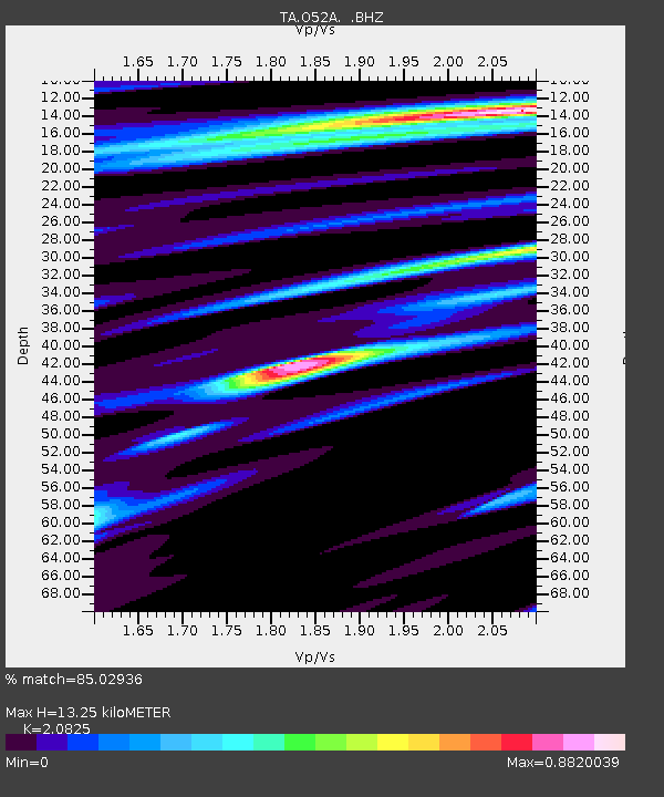
| Estimated Moho Depth: |
13.25 km |
| Estimated Crust Vp/Vs: |
2.08 |
| Assumed Crust Vp: |
6.483 km/s |
| Estimated Crust Vs: |
3.113 km/s |
| Estimated Crust Poisson's Ratio: |
0.35 |
|
| Radial Match: |
85.02936 % |
| Radial Bump: |
400 |
| Transverse Match: |
51.199074 % |
| Transverse Bump: |
400 |
| SOD ConfigId: |
626651 |
| Insert Time: |
2014-06-15 05:41:15.555 +0000 |
| GWidth: |
2.5 |
| Max Bumps: |
400 |
| Tol: |
0.001 |
|

Signal To Noise
| Channel | StoN | STA | LTA |
| TA:O52A: :BHZ:20140523T23:48:48.774989Z | 7.0145493 | 3.339206E-7 | 4.7604E-8 |
| TA:O52A: :BHN:20140523T23:48:48.774989Z | 1.6340537 | 1.0667687E-7 | 6.528357E-8 |
| TA:O52A: :BHE:20140523T23:48:48.774989Z | 1.963109 | 1.5408314E-7 | 7.848934E-8 |
| Arrivals |
| Ps | 2.4 SECOND |
| PpPs | 5.9 SECOND |
| PsPs/PpSs | 8.3 SECOND |


