You are here: Home > Network List > TA - USArray Transportable Network (new EarthScope stations) Stations List
> Station P60A Greenville, DE, USA > Earthquake Result Viewer
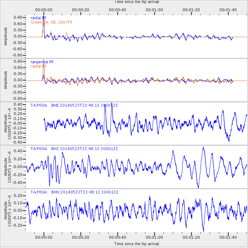
P60A Greenville, DE, USA - Earthquake Result Viewer
*The percent match for this event was below the threshold and hence no stack was calculated.
| Earthquake location: |
Northern Mid-Atlantic Ridge |
| Earthquake latitude/longitude: |
45.0/-27.8 |
| Earthquake time(UTC): |
2014/05/23 (143) 23:41:49 GMT |
| Earthquake Depth: |
10 km |
| Earthquake Magnitude: |
5.5 MWC, 5.5 MWC |
| Earthquake Catalog/Contributor: |
NEIC PDE/NEIC COMCAT |
|
| Network: |
TA USArray Transportable Network (new EarthScope stations) |
| Station: |
P60A Greenville, DE, USA |
| Lat/Lon: |
39.81 N/75.64 W |
| Elevation: |
105 m |
|
| Distance: |
35.3 deg |
| Az: |
278.695 deg |
| Baz: |
65.486 deg |
| Ray Param: |
$rayparam |
*The percent match for this event was below the threshold and hence was not used in the summary stack. |
|
| Radial Match: |
71.15915 % |
| Radial Bump: |
400 |
| Transverse Match: |
58.76373 % |
| Transverse Bump: |
400 |
| SOD ConfigId: |
626651 |
| Insert Time: |
2014-06-15 05:42:51.168 +0000 |
| GWidth: |
2.5 |
| Max Bumps: |
400 |
| Tol: |
0.001 |
|
Signal To Noise
| Channel | StoN | STA | LTA |
| TA:P60A: :BHZ:20140523T23:48:13.300013Z | 2.5572653 | 1.8087066E-7 | 7.0728156E-8 |
| TA:P60A: :BHN:20140523T23:48:13.300013Z | 0.86425316 | 7.014527E-8 | 8.1162874E-8 |
| TA:P60A: :BHE:20140523T23:48:13.300013Z | 2.404365 | 1.5898375E-7 | 6.6122965E-8 |
| Arrivals |
| Ps | |
| PpPs | |
| PsPs/PpSs | |


