You are here: Home > Network List > TA - USArray Transportable Network (new EarthScope stations) Stations List
> Station W58A Raeford, NC, USA > Earthquake Result Viewer
W58A Raeford, NC, USA - Earthquake Result Viewer
| Earthquake location: |
Northern Mid-Atlantic Ridge |
| Earthquake latitude/longitude: |
45.0/-27.8 |
| Earthquake time(UTC): |
2014/05/23 (143) 23:41:49 GMT |
| Earthquake Depth: |
10 km |
| Earthquake Magnitude: |
5.5 MWC, 5.5 MWC |
| Earthquake Catalog/Contributor: |
NEIC PDE/NEIC COMCAT |
|
| Network: |
TA USArray Transportable Network (new EarthScope stations) |
| Station: |
W58A Raeford, NC, USA |
| Lat/Lon: |
35.02 N/79.23 W |
| Elevation: |
84 m |
|
| Distance: |
40.0 deg |
| Az: |
273.918 deg |
| Baz: |
59.52 deg |
| Ray Param: |
0.07464361 |
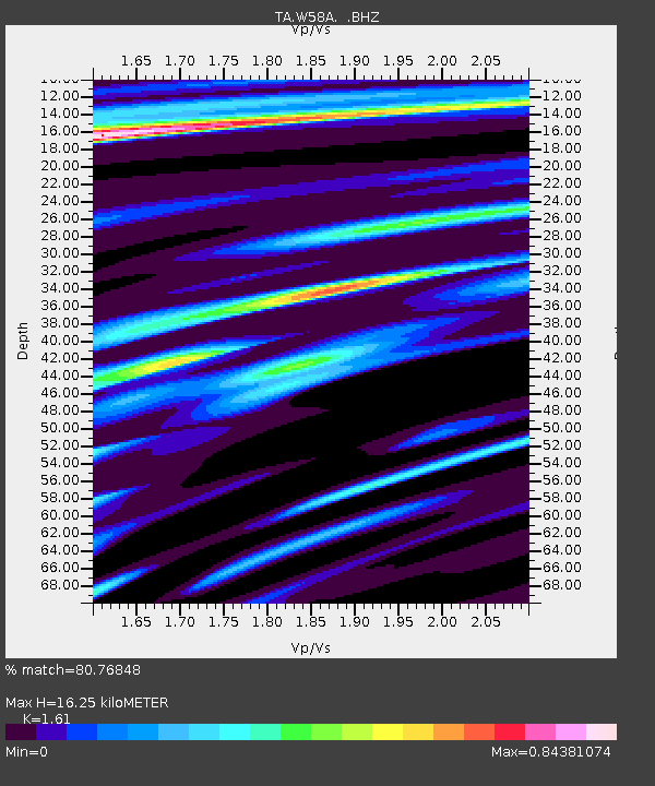
| Estimated Moho Depth: |
16.25 km |
| Estimated Crust Vp/Vs: |
1.61 |
| Assumed Crust Vp: |
6.565 km/s |
| Estimated Crust Vs: |
4.077 km/s |
| Estimated Crust Poisson's Ratio: |
0.19 |
|
| Radial Match: |
80.76848 % |
| Radial Bump: |
400 |
| Transverse Match: |
51.41026 % |
| Transverse Bump: |
400 |
| SOD ConfigId: |
626651 |
| Insert Time: |
2014-06-15 05:46:46.104 +0000 |
| GWidth: |
2.5 |
| Max Bumps: |
400 |
| Tol: |
0.001 |
|
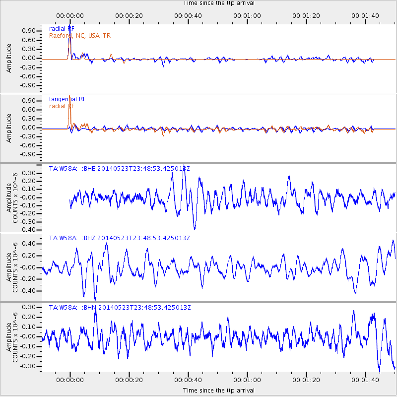
Signal To Noise
| Channel | StoN | STA | LTA |
| TA:W58A: :BHZ:20140523T23:48:53.425013Z | 2.7622151 | 2.0392531E-7 | 7.382673E-8 |
| TA:W58A: :BHN:20140523T23:48:53.425013Z | 1.2198884 | 7.771354E-8 | 6.370544E-8 |
| TA:W58A: :BHE:20140523T23:48:53.425013Z | 2.434738 | 1.1803621E-7 | 4.8480047E-8 |
| Arrivals |
| Ps | 1.6 SECOND |
| PpPs | 6.0 SECOND |
| PsPs/PpSs | 7.6 SECOND |


