You are here: Home > Network List > TA - USArray Transportable Network (new EarthScope stations) Stations List
> Station Z41A Richland Creek Farm, El Dorado, AR, USA > Earthquake Result Viewer
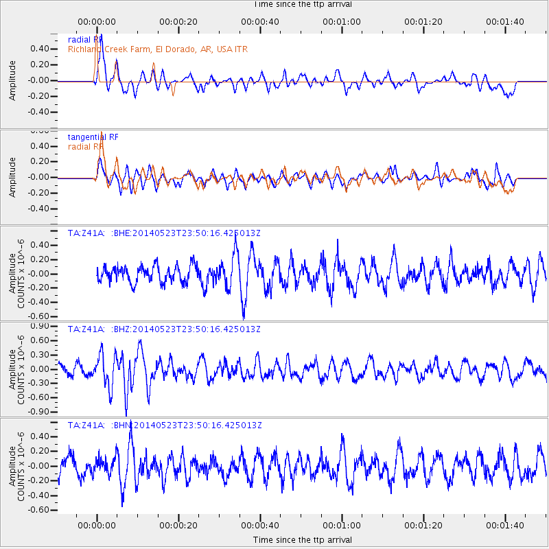
Z41A Richland Creek Farm, El Dorado, AR, USA - Earthquake Result Viewer
*The percent match for this event was below the threshold and hence no stack was calculated.
| Earthquake location: |
Northern Mid-Atlantic Ridge |
| Earthquake latitude/longitude: |
45.0/-27.8 |
| Earthquake time(UTC): |
2014/05/23 (143) 23:41:49 GMT |
| Earthquake Depth: |
10 km |
| Earthquake Magnitude: |
5.5 MWC, 5.5 MWC |
| Earthquake Catalog/Contributor: |
NEIC PDE/NEIC COMCAT |
|
| Network: |
TA USArray Transportable Network (new EarthScope stations) |
| Station: |
Z41A Richland Creek Farm, El Dorado, AR, USA |
| Lat/Lon: |
33.26 N/92.80 W |
| Elevation: |
62 m |
|
| Distance: |
50.5 deg |
| Az: |
280.227 deg |
| Baz: |
56.378 deg |
| Ray Param: |
$rayparam |
*The percent match for this event was below the threshold and hence was not used in the summary stack. |
|
| Radial Match: |
70.35095 % |
| Radial Bump: |
400 |
| Transverse Match: |
69.07232 % |
| Transverse Bump: |
400 |
| SOD ConfigId: |
626651 |
| Insert Time: |
2014-06-15 05:47:42.986 +0000 |
| GWidth: |
2.5 |
| Max Bumps: |
400 |
| Tol: |
0.001 |
|
Signal To Noise
| Channel | StoN | STA | LTA |
| TA:Z41A: :BHZ:20140523T23:50:16.425013Z | 2.6010845 | 3.4555896E-7 | 1.3285188E-7 |
| TA:Z41A: :BHN:20140523T23:50:16.425013Z | 0.98353505 | 1.10657716E-7 | 1.1251019E-7 |
| TA:Z41A: :BHE:20140523T23:50:16.425013Z | 2.0789075 | 2.3332001E-7 | 1.1223202E-7 |
| Arrivals |
| Ps | |
| PpPs | |
| PsPs/PpSs | |


