You are here: Home > Network List > II - Global Seismograph Network (GSN - IRIS/IDA) Stations List
> Station ABKT Alibek, Turkmenistan > Earthquake Result Viewer
ABKT Alibek, Turkmenistan - Earthquake Result Viewer
| Earthquake location: |
South Of Java, Indonesia |
| Earthquake latitude/longitude: |
-10.5/113.0 |
| Earthquake time(UTC): |
1994/06/02 (153) 18:17:36 GMT |
| Earthquake Depth: |
39 km |
| Earthquake Magnitude: |
5.5 MB, 7.2 MS, 6.8 UNKNOWN, 7.7 MW |
| Earthquake Catalog/Contributor: |
WHDF/NEIC |
|
| Network: |
II Global Seismograph Network (GSN - IRIS/IDA) |
| Station: |
ABKT Alibek, Turkmenistan |
| Lat/Lon: |
37.93 N/58.12 E |
| Elevation: |
678 m |
|
| Distance: |
70.3 deg |
| Az: |
316.621 deg |
| Baz: |
121.319 deg |
| Ray Param: |
0.05500963 |
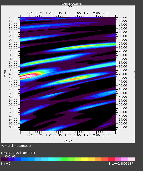
| Estimated Moho Depth: |
41.0 km |
| Estimated Crust Vp/Vs: |
1.63 |
| Assumed Crust Vp: |
6.53 km/s |
| Estimated Crust Vs: |
4.006 km/s |
| Estimated Crust Poisson's Ratio: |
0.20 |
|
| Radial Match: |
98.59273 % |
| Radial Bump: |
381 |
| Transverse Match: |
92.49274 % |
| Transverse Bump: |
400 |
| SOD ConfigId: |
61242 |
| Insert Time: |
2010-03-01 22:49:16.267 +0000 |
| GWidth: |
2.5 |
| Max Bumps: |
400 |
| Tol: |
0.001 |
|

Signal To Noise
| Channel | StoN | STA | LTA |
| II:ABKT:00:BHN:19940602T18:28:15.370007Z | 2.6784022 | 9.229821E-8 | 3.4460175E-8 |
| II:ABKT:00:BHE:19940602T18:28:15.370007Z | 3.4870315 | 1.05545176E-7 | 3.0267916E-8 |
| II:ABKT:00:BHZ:19940602T18:28:15.370007Z | 4.898522 | 2.3132668E-7 | 4.722377E-8 |
| Arrivals |
| Ps | 4.1 SECOND |
| PpPs | 16 SECOND |
| PsPs/PpSs | 20 SECOND |


