You are here: Home > Network List > TJ - Tajikistan National Seismic Network Stations List
> Station SHAA Shaartuz, Tajikistan > Earthquake Result Viewer
SHAA Shaartuz, Tajikistan - Earthquake Result Viewer
| Earthquake location: |
North Indian Ocean |
| Earthquake latitude/longitude: |
2.0/89.7 |
| Earthquake time(UTC): |
2014/06/01 (152) 10:07:11 GMT |
| Earthquake Depth: |
14 km |
| Earthquake Magnitude: |
5.6 M |
| Earthquake Catalog/Contributor: |
NEIC PDE/NEIC COMCAT |
|
| Network: |
TJ Tajikistan National Seismic Network |
| Station: |
SHAA Shaartuz, Tajikistan |
| Lat/Lon: |
37.56 N/68.12 E |
| Elevation: |
868 m |
|
| Distance: |
40.6 deg |
| Az: |
333.253 deg |
| Baz: |
145.528 deg |
| Ray Param: |
0.07430552 |
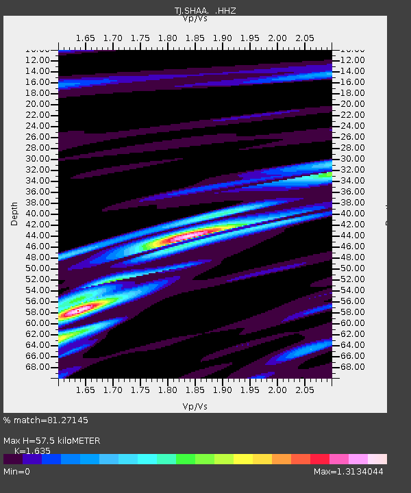
| Estimated Moho Depth: |
57.5 km |
| Estimated Crust Vp/Vs: |
1.63 |
| Assumed Crust Vp: |
6.213 km/s |
| Estimated Crust Vs: |
3.8 km/s |
| Estimated Crust Poisson's Ratio: |
0.20 |
|
| Radial Match: |
81.27145 % |
| Radial Bump: |
400 |
| Transverse Match: |
80.72946 % |
| Transverse Bump: |
400 |
| SOD ConfigId: |
626651 |
| Insert Time: |
2014-06-15 10:30:24.655 +0000 |
| GWidth: |
2.5 |
| Max Bumps: |
400 |
| Tol: |
0.001 |
|
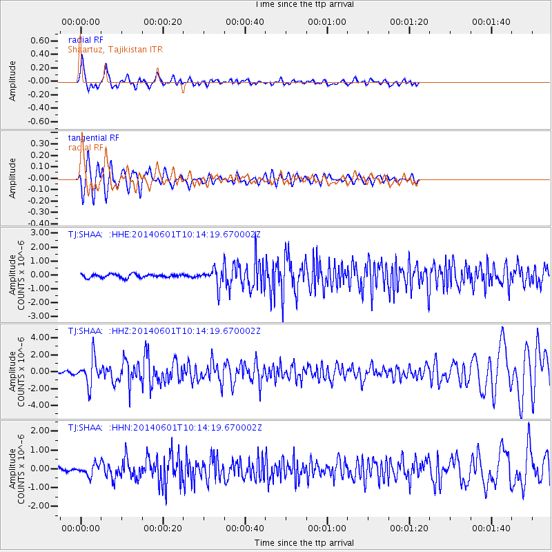
Signal To Noise
| Channel | StoN | STA | LTA |
| TJ:SHAA: :HHZ:20140601T10:14:19.670002Z | 11.599821 | 1.6307841E-6 | 1.40587E-7 |
| TJ:SHAA: :HHN:20140601T10:14:19.670002Z | 3.579531 | 2.899355E-7 | 8.099819E-8 |
| TJ:SHAA: :HHE:20140601T10:14:19.670002Z | 4.998165 | 6.4225543E-7 | 1.2849823E-7 |
| Arrivals |
| Ps | 6.3 SECOND |
| PpPs | 23 SECOND |
| PsPs/PpSs | 29 SECOND |


