You are here: Home > Network List > II - Global Seismograph Network (GSN - IRIS/IDA) Stations List
> Station ABKT Alibek, Turkmenistan > Earthquake Result Viewer
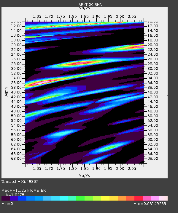
ABKT Alibek, Turkmenistan - Earthquake Result Viewer
| Earthquake location: |
Halmahera, Indonesia |
| Earthquake latitude/longitude: |
-1.2/128.0 |
| Earthquake time(UTC): |
1994/10/08 (281) 21:44:09 GMT |
| Earthquake Depth: |
31 km |
| Earthquake Magnitude: |
6.3 MB, 6.8 MS, 6.8 UNKNOWN, 6.9 MW |
| Earthquake Catalog/Contributor: |
WHDF/NEIC |
|
| Network: |
II Global Seismograph Network (GSN - IRIS/IDA) |
| Station: |
ABKT Alibek, Turkmenistan |
| Lat/Lon: |
37.93 N/58.12 E |
| Elevation: |
678 m |
|
| Distance: |
75.0 deg |
| Az: |
309.762 deg |
| Baz: |
103.614 deg |
| Ray Param: |
0.051924963 |
| Estimated Moho Depth: |
11.25 km |
| Estimated Crust Vp/Vs: |
1.83 |
| Assumed Crust Vp: |
6.53 km/s |
| Estimated Crust Vs: |
3.573 km/s |
| Estimated Crust Poisson's Ratio: |
0.29 |
|
| Radial Match: |
95.49867 % |
| Radial Bump: |
400 |
| Transverse Match: |
93.240166 % |
| Transverse Bump: |
400 |
| SOD ConfigId: |
61242 |
| Insert Time: |
2010-03-01 22:49:40.016 +0000 |
| GWidth: |
2.5 |
| Max Bumps: |
400 |
| Tol: |
0.001 |
|

Signal To Noise
| Channel | StoN | STA | LTA |
| II:ABKT:00:BHN:19941008T21:55:16.326013Z | 0.820738 | 2.5352252E-8 | 3.0889577E-8 |
| II:ABKT:00:BHE:19941008T21:55:16.326013Z | 1.7699353 | 8.2683464E-8 | 4.6715527E-8 |
| II:ABKT:00:BHZ:19941008T21:55:16.326013Z | 3.779028 | 2.2025304E-7 | 5.8282993E-8 |
| Arrivals |
| Ps | 1.5 SECOND |
| PpPs | 4.7 SECOND |
| PsPs/PpSs | 6.2 SECOND |


