You are here: Home > Network List > II - Global Seismograph Network (GSN - IRIS/IDA) Stations List
> Station ABKT Alibek, Turkmenistan > Earthquake Result Viewer
ABKT Alibek, Turkmenistan - Earthquake Result Viewer
| Earthquake location: |
Kuril Islands |
| Earthquake latitude/longitude: |
43.9/147.9 |
| Earthquake time(UTC): |
1994/10/09 (282) 07:55:38 GMT |
| Earthquake Depth: |
23 km |
| Earthquake Magnitude: |
6.5 MB, 7.0 MS, 6.7 UNKNOWN, 7.3 MW |
| Earthquake Catalog/Contributor: |
WHDF/NEIC |
|
| Network: |
II Global Seismograph Network (GSN - IRIS/IDA) |
| Station: |
ABKT Alibek, Turkmenistan |
| Lat/Lon: |
37.93 N/58.12 E |
| Elevation: |
678 m |
|
| Distance: |
64.8 deg |
| Az: |
299.119 deg |
| Baz: |
53.0 deg |
| Ray Param: |
0.058633763 |
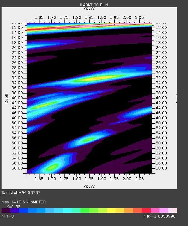
| Estimated Moho Depth: |
10.5 km |
| Estimated Crust Vp/Vs: |
1.95 |
| Assumed Crust Vp: |
6.53 km/s |
| Estimated Crust Vs: |
3.349 km/s |
| Estimated Crust Poisson's Ratio: |
0.32 |
|
| Radial Match: |
96.56767 % |
| Radial Bump: |
400 |
| Transverse Match: |
76.33522 % |
| Transverse Bump: |
400 |
| SOD ConfigId: |
61242 |
| Insert Time: |
2010-03-01 22:49:43.100 +0000 |
| GWidth: |
2.5 |
| Max Bumps: |
400 |
| Tol: |
0.001 |
|

Signal To Noise
| Channel | StoN | STA | LTA |
| II:ABKT:00:BHN:19941009T08:05:44.028015Z | 7.3517327 | 5.10583E-7 | 6.94507E-8 |
| II:ABKT:00:BHE:19941009T08:05:44.028015Z | 10.624416 | 5.929664E-7 | 5.5811665E-8 |
| II:ABKT:00:BHZ:19941009T08:05:44.028015Z | 26.224567 | 2.5020274E-6 | 9.540776E-8 |
| Arrivals |
| Ps | 1.6 SECOND |
| PpPs | 4.6 SECOND |
| PsPs/PpSs | 6.1 SECOND |


