ABKT Alibek, Turkmenistan - Earthquake Result Viewer
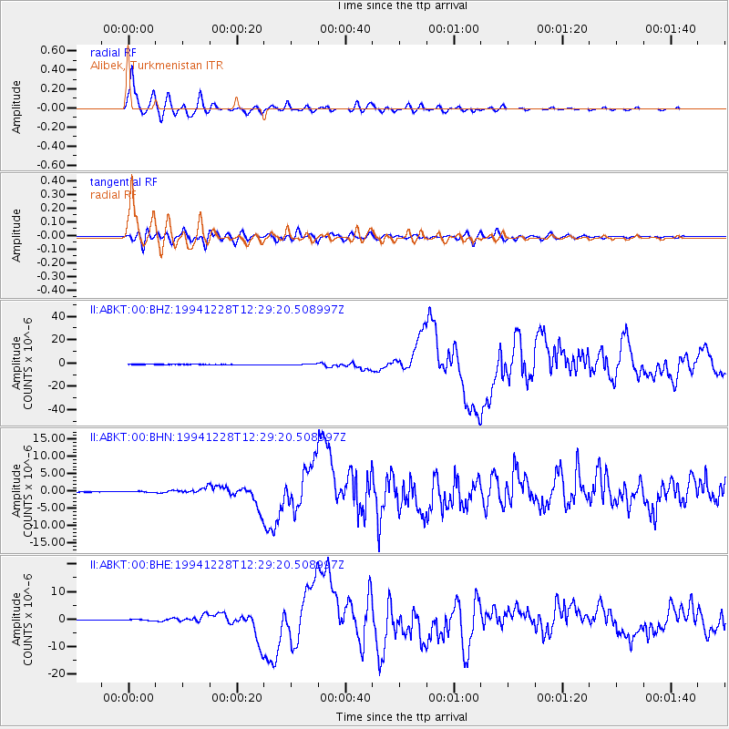
Earthquake location: Off East Coast Of Honshu, Japan
Earthquake latitude/longitude: 40.5/143.5
Earthquake time(UTC): 1994/12/28 (362) 12:19:23 GMT
Earthquake Depth: 33 km
Earthquake Magnitude: 6.4 MB, 7.5 MS, 7.2 UNKNOWN, 7.7 MW
Earthquake Catalog/Contributor: WHDF/NEIC
Network: II Global Seismograph Network (GSN - IRIS/IDA)
Station: ABKT Alibek, Turkmenistan
Lat/Lon: 37.93 N/58.12 E
Elevation: 678 m
Distance: 63.6 deg
Az: 298.385 deg
Baz: 58.105 deg
Ray Param: 0.05940435
Estimated Moho Depth: 11.5 km
Estimated Crust Vp/Vs: 1.81
Assumed Crust Vp: 6.53 km/s
Estimated Crust Vs: 3.618 km/s
Estimated Crust Poisson's Ratio: 0.28
Radial Match: 97.46143 %
Radial Bump: 400
Transverse Match: 80.650505 %
Transverse Bump: 400
SOD ConfigId: 61242
Insert Time: 2010-03-01 22:49:53.484 +0000
GWidth: 2.5
Max Bumps: 400
Tol: 0.001

Signal To Noise

ChannelStoNSTALTA
II:ABKT:00:BHN:19941228T12:29:20.508997Z2.7132331.6917271E-76.235097E-8
II:ABKT:00:BHE:19941228T12:29:20.508997Z3.11318092.396076E-77.696552E-8
II:ABKT:00:BHZ:19941228T12:29:20.508997Z5.54917865.276053E-79.507809E-8
Arrivals
Ps1.5 SECOND
PpPs4.7 SECOND
PsPs/PpSs6.2 SECOND