You are here: Home > Network List > LD - Lamont-Doherty Cooperative Seismographic Network Stations List
> Station LUPA Lehigh University, PA > Earthquake Result Viewer
LUPA Lehigh University, PA - Earthquake Result Viewer
| Earthquake location: |
Southeastern Alaska |
| Earthquake latitude/longitude: |
59.0/-136.7 |
| Earthquake time(UTC): |
2014/06/04 (155) 11:58:58 GMT |
| Earthquake Depth: |
10 km |
| Earthquake Magnitude: |
5.7 MWP, 5.8 ML, 5.8 MI |
| Earthquake Catalog/Contributor: |
NEIC PDE/NEIC COMCAT |
|
| Network: |
LD Lamont-Doherty Cooperative Seismographic Network |
| Station: |
LUPA Lehigh University, PA |
| Lat/Lon: |
40.60 N/75.37 W |
| Elevation: |
236 m |
|
| Distance: |
41.9 deg |
| Az: |
88.072 deg |
| Baz: |
317.207 deg |
| Ray Param: |
0.07348144 |
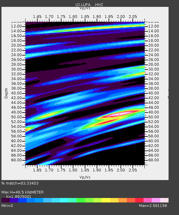
| Estimated Moho Depth: |
48.5 km |
| Estimated Crust Vp/Vs: |
1.99 |
| Assumed Crust Vp: |
6.283 km/s |
| Estimated Crust Vs: |
3.153 km/s |
| Estimated Crust Poisson's Ratio: |
0.33 |
|
| Radial Match: |
83.33403 % |
| Radial Bump: |
346 |
| Transverse Match: |
82.794014 % |
| Transverse Bump: |
355 |
| SOD ConfigId: |
626651 |
| Insert Time: |
2014-06-18 12:22:31.436 +0000 |
| GWidth: |
2.5 |
| Max Bumps: |
400 |
| Tol: |
0.001 |
|

Signal To Noise
| Channel | StoN | STA | LTA |
| LD:LUPA: :HHZ:20140604T12:06:17.999988Z | 2.8500578 | 2.8165985E-8 | 9.882601E-9 |
| LD:LUPA: :HHN:20140604T12:06:17.999988Z | 1.1264219 | 3.5564205E-9 | 3.157272E-9 |
| LD:LUPA: :HHE:20140604T12:06:17.999988Z | 1.8980207 | 9.486641E-8 | 4.9981754E-8 |
| Arrivals |
| Ps | 8.1 SECOND |
| PpPs | 22 SECOND |
| PsPs/PpSs | 30 SECOND |


