You are here: Home > Network List > TA - USArray Transportable Network (new EarthScope stations) Stations List
> Station I23K Minto, Yukon-Koyukuk, AK, USA > Earthquake Result Viewer
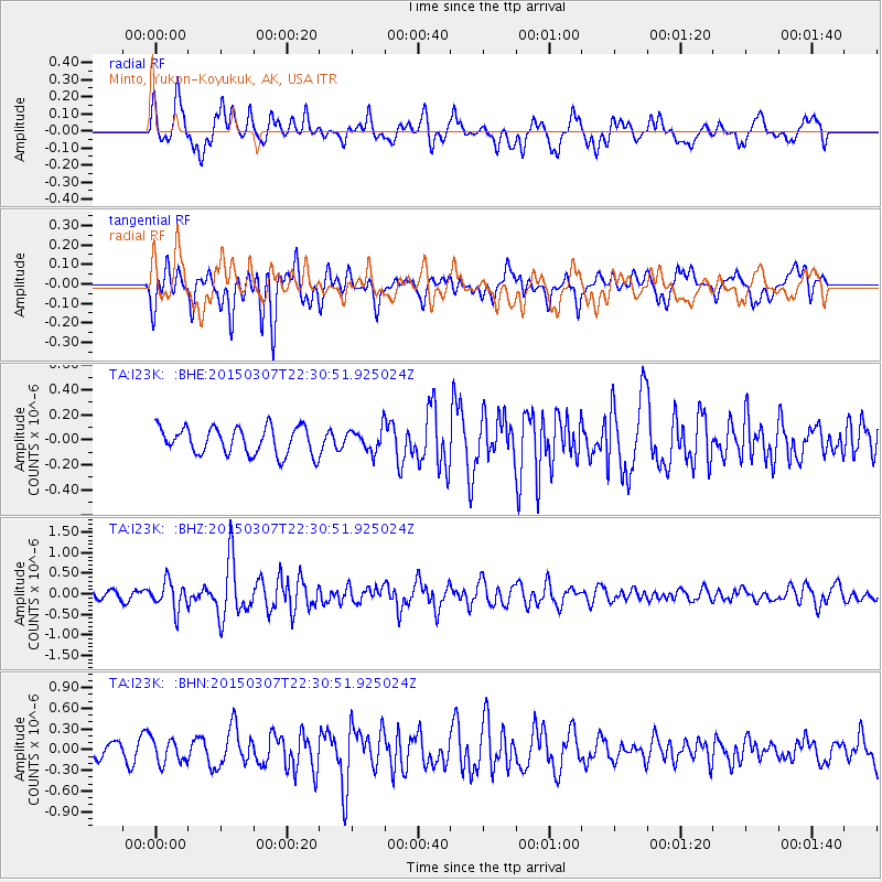
I23K Minto, Yukon-Koyukuk, AK, USA - Earthquake Result Viewer
*The percent match for this event was below the threshold and hence no stack was calculated.
| Earthquake location: |
New Britain Region, P.N.G. |
| Earthquake latitude/longitude: |
-6.6/151.7 |
| Earthquake time(UTC): |
2015/03/07 (066) 22:18:58 GMT |
| Earthquake Depth: |
23 km |
| Earthquake Magnitude: |
6.0 MB |
| Earthquake Catalog/Contributor: |
NEIC PDE/NEIC COMCAT |
|
| Network: |
TA USArray Transportable Network (new EarthScope stations) |
| Station: |
I23K Minto, Yukon-Koyukuk, AK, USA |
| Lat/Lon: |
65.15 N/149.36 W |
| Elevation: |
149 m |
|
| Distance: |
83.4 deg |
| Az: |
21.362 deg |
| Baz: |
238.912 deg |
| Ray Param: |
$rayparam |
*The percent match for this event was below the threshold and hence was not used in the summary stack. |
|
| Radial Match: |
66.87866 % |
| Radial Bump: |
400 |
| Transverse Match: |
49.293148 % |
| Transverse Bump: |
400 |
| SOD ConfigId: |
7019011 |
| Insert Time: |
2019-04-17 06:05:26.716 +0000 |
| GWidth: |
2.5 |
| Max Bumps: |
400 |
| Tol: |
0.001 |
|
Signal To Noise
| Channel | StoN | STA | LTA |
| TA:I23K: :BHZ:20150307T22:30:51.925024Z | 2.2349625 | 3.4313172E-7 | 1.5352907E-7 |
| TA:I23K: :BHN:20150307T22:30:51.925024Z | 0.9678125 | 1.7556331E-7 | 1.8140221E-7 |
| TA:I23K: :BHE:20150307T22:30:51.925024Z | 0.92353123 | 9.959324E-8 | 1.078396E-7 |
| Arrivals |
| Ps | |
| PpPs | |
| PsPs/PpSs | |


